The map room
The 1860 wall map
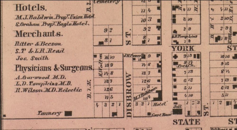
In 1860 Geil, Harley & Siverd of Philadelphia engraved a great wall map of Cass, Van Buren and Berrien counties, Michigan: every township, the farms and the names of the people on them, with little town plans and pictures of houses around the border. The original is at the Library of Congress. Here you can walk over every inch of it.
Drag to move. Scroll, pinch or use the buttons to zoom. Nothing is marked: the hunt is yours.
Then and now. The old town plans laid over today’s streets: CassopolisNilesDowagiacPaw PawSouth Bend, 1863Goshen, 1861Elkhart, 1861All seven →
Names on the old maps. Every lawyer, doctor, merchant and smith in the directories beside the town plans, in one roll you can search: Who was in town →
Jump to a town plan (or see them all in the gazetteer): Buchanan Berrien Springs Decatur Edwardsburg Lawton St. Joseph Coloma Hartford Lawrence Mattawan · on their county maps: Three Rivers Constantine Centreville White Pigeon Kalamazoo · Indiana, 1863: South Bend Mishawaka Roseland Granger Osceola New Carlisle Lakeville North Liberty Walkerton · bird’s-eye views: Niles 1868 South Bend 1866 1874 1890 Kalamazoo 1874 Benton Harbor 1889 Grand Rapids 1868 · Sanborn sheets · Elkhart County, 1861: Elkhart Goshen Bristol Middlebury Wakarusa · and Benton Harbor Grand Rapids · laid over today’s streets: Cassopolis Dowagiac Niles Paw Paw South Bend Goshen Elkhart
Sanborn fire-insurance maps, building by building
From the 1880s the Sanborn Map Company drew every business block for the insurers: each building’s outline, what it was built of (pink for brick, yellow for wood), how many storeys, and what went on inside: a livery, a hall, a hotel. Twelve towns on the trail have them. Choose a town and a sheet, and it opens in the viewer above.
The sheets are the Library of Congress’s scans, shown from Wikimedia Commons. Public domain.
Old postcards on the map
121 old postcards and photographs of 29 towns, each pinned where it was taken. Press a town to see its pictures, then open any one in the postcards gallery.
The map loads here.
Things to look for
- The small town plans along the top and left side, with streets, blocks and the names of buildings.
- The business directories printed in the margins, listing who kept which shop or hotel.
- The engraved houses around the border: the proudest farms and homes of 1860.
- Every farm, marked with its owner’s name and acreage. Find your family’s name on the land in 1860, then look for the same name in the deed books.
More maps in the room


The county, township by township, about 1928
All fifteen of the county’s townships from a plat book of about 1928, each farm with its owner’s name and acreage, two generations after the 1860 map. Open a sheet and read the names; then look for the same names on the wall map above. Penn Township is laid over its 1860 self on a slider on the Cassopolis page, with ten families to find.
Source: a plat book of Cass County, Michigan, of about 1928, from the scans contributed by Ross Traverse to the Cass County MIGenWeb Project. Published before 1929 and so in the public domain.
Also in the viewer, from the Library of Congress’s county landownership maps: the 1858 map of St. Joseph County, Michigan (g4113s.la000356), and Geil & Harley’s map of Kalamazoo County (g4113k.la000336). Also, from the Library of Congress: Map of St. Joseph Co., Indiana, compiled and published by M. W. Stokes (South Bend, 1863), engraved by Chas. Shober of Chicago, views by Jas. Bonney (Library of Congress, item 2013593163). Public domain. Shown live from their holders, with thanks: Geil & Harley’s Map of Elkhart Co. Indiana (Philadelphia: Samuel Geil, 1861), surveyed by Joseph D. Nash, from the American Geographical Society Library, University of Wisconsin–Milwaukee Libraries; W. W. Graves, Atlas of Berrien County, Michigan (Rand McNally), and R. L. Polk & Co.’s Illustrated Historical Atlas of Kent County, Michigan (1894), from the University of Michigan Library.
Source: Map of the Counties of Cass, Van Buren and Berrien, Michigan (Philadelphia: Geil, Harley & Siverd, 1860). Library of Congress, Geography and Map Division, g4113c.la000324. Public domain. Shown through the Library’s own image service.