Museums & historic places
Where the valley keeps its past
Here are 141 museums, historic houses, libraries, research rooms and archives across the St. Joseph River valley and its neighbours, from the log cabin in Cassopolis to the Studebaker collection in South Bend. The hunt starts on this website. It finishes in places like these.
The map opens here: 138 of the 141 places have a pin, and places in the same building share one.
My passport 0 stamps
A stamp is earned by pressing “I’m here” at the place itself. Your browser checks your location once; it stays on this device. See your whole passport, with the walks, tables and festivals too.
Day trips
Six ready-made days out. Load one, press “Best order”, and check each place’s hours before you go.
Studebaker and South Bend
Wagons, cars and the families who built them, all within a few blocks of the river.
A Cass County loop
The county seat and the towns around it: a cabin, a stove town, a fishing-lure maker and an old filling station.
Niles and the river
Fort St. Joseph, the four flags and the mills and courthouse down the St. Joseph.
Lighthouses and the lake shore
From Michigan City up the shore to South Haven: lights, railroads and the people of the big lake.
Amish country
Shipshewana, Middlebury, Bristol and Nappanee: the plain people, a mill and a kitchen-cabinet town.
A Kalamazoo day
The valley’s big neighbour: its museum, its park, its old cemetery and an air museum to finish.
Nearest to you
Cass County, Michigan 16 places
-
Society · Cassopolis
Cass County Historical Society
The county historical society. It runs the Newton House museum together with the county and publishes books on Cass County history.
For researchers: Its publications are sold through the Cass District Library Local History Branch.
Email ccmihistoricalsociety@gmail.com.
P.O. Box 21, Cassopolis, MI 49031
-
Library history room · Cassopolis
Cass District Library – Local History Branch
A branch library given over to Cass County history and genealogy.
For researchers: Plat maps, county newspapers on microfilm (Cassopolis, Dowagiac, Edwardsburg, Marcellus, Niles titles), obituary indexes 1998–2025, marriage, death and divorce records on microfilm, cemetery and rural-school guides, yearbooks and a vertical file.
Mon–Thu 9–4; closed Fri–Sun. Phone 269-357-7823.
145 N. Broadway, Cassopolis, MI 49031
-
Library · Cassopolis
Cass District Library – Main Branch
The main library of the system that serves most of Cass County’s townships, with Ancestry Library Edition for family history.
For researchers: Local history is kept at the Local History Branch on Broadway.
See the library’s website for hours.
319 M-62, Cassopolis, MI 49031
-
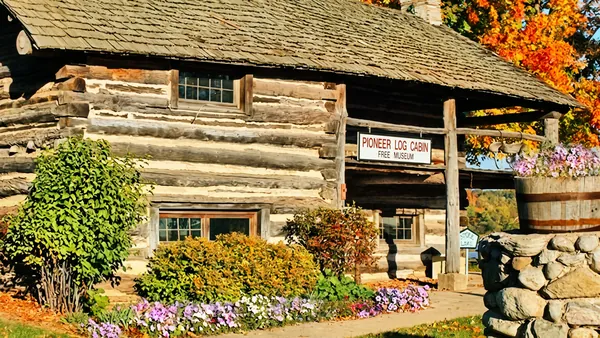
Museum · Cassopolischeck before you go
Pioneer Log Cabin Museum
A log cabin museum in Cassopolis, kept by volunteers, holding pioneer-era objects from Cass County.
Saturdays and Sundays, Memorial Day through Labor Day.
400 S. Broadway St., Cassopolis, MI
Community page › · Directions · Cassopolis on the 1860 map ·
-
Historic site · Cassopolis
Sinclair Station
A filling station restored in the style of the 1950s and 1960s, a roadside display of mid-century motoring that visitors are welcome to look over.
A private showplace; look over it from outside or ask on site.
200 S. Broadway St., Cassopolis, MI 49031
-
Historic house · Decatur (Volinia Township)
Newton House
A historic farmhouse museum with permanent and changing displays on daily life from 1844 to 1930, when the Newton family lived there.
For researchers: Several rooms are set aside for reading and research on the family, the surrounding woods and local history; it also keeps documents, family histories and artifacts.
Open houses on the first Sunday of each month, June to September, 1:00–4:30 pm.
20689 Marcellus Hwy, Decatur, MI 49045
-
Museum · Dowagiac
Dowagiac Area History Museum
A free museum with about 6,000 square feet of exhibits on the history of Dowagiac, Cass County and the surrounding area, including the Round Oak stove story and an Orphan Train exhibit.
For researchers: Online collections database; ask the museum about research use (269-783-2560, info@dowagiacmuseum.info).
Tue–Fri 10–5, Sat 10–2. Free.
201 E. Division St., Dowagiac, MI 49047
-
Library history room · Dowagiac
Dowagiac District Library – Genealogy & Local History
The public library for Dowagiac, with books, microfilm and digital resources for genealogy and local history.
For researchers: Questions to genealogy@dowagiacdl.org.
Mon/Wed/Fri 9–5:30, Tue/Thu 9–7, Sat 9–2.
211 Commercial St., Dowagiac, MI 49047
-
Museum · Dowagiac
Heddon Museum
The museum of James Heddon’s Sons, the Dowagiac fishing-tackle company famous for its lures, rods and reels, with a recreated workshop showing how lures were made by hand.
Tuesday and Friday 10–5; run by volunteers, so call ahead: 269-783-2560.
115 S. Front St., Dowagiac, MI 49047
-
Library · Edwardsburg
Cass District Library – Edwardsburg Branch
A branch of the Cass District Library.
See the library’s website for hours.
26745 Church St., Edwardsburg, MI
-
Library · Edwardsburg
Cass District Library – Mason/Union Branch
A branch of the Cass District Library.
See the library’s website for hours.
17049 US-12, Edwardsburg, MI
-
Museum · Edwardsburg
Edwardsburg Area History Museum
A community history museum in a donated house on Main Street, with displays and talks on Edwardsburg-area history.
For researchers: Contact the museum about research (269-663-3005, edwardsburgmuseum@yahoo.com).
Open mid-April to mid-December; Tue–Fri 1–4, Sat 11–2.
26818 Main Street, Edwardsburg, MI 49112
-
Library · Marcellus
Marcellus Township Wood Memorial Library
The township library for the Village of Marcellus and Marcellus Township.
For researchers: Bound copies of the Marcellus News, 1995–2024, which staff will scan for you.
Mon–Thu 10–7, Fri 10–5, Sat 10–2.
205 E. Main St., Marcellus, MI 49067
-
Museum · Marcellus
Veterans Museum at VFW Post 4054
A veterans’ military museum at the Marcellus VFW post, with a memorial to the area’s missing in action.
Ask the post about visiting hours.
4054 Centre St. (M-40), Marcellus, MI 49067
-
Library · Niles (Howard Twp.)
Cass District Library – Howard Branch
A branch of the Cass District Library.
See the library’s website for hours.
2341 Yankee St., Niles, MI
-
Historic house · Vandalia
Bonine House
A restored nineteenth-century home in Vandalia, open as a museum with docent-led visits. It tells the story of Cass County's part in the Underground Railroad, and its seasonal events include a Christmas open house.
May to October, Mon–Fri 2–5 pm; private tours by arrangement.
18970 M-60, Vandalia, MI 49095
Berrien County, Michigan 13 places
-
Archive · Benton Harbor
Fort Miami Heritage Society Archive
The archive of the society that ran the Heritage Museum and Cultural Center in St. Joseph from 1997 to 2025, holding thousands of documents and photographs on St. Joseph, Benton Harbor and the area.
For researchers: Research requests by email (info@fortmiamiheritage.org); the online catalog can be browsed.
No posted public hours: write to the society before visiting.
777 Riverview Drive, Suite 109D, Benton Harbor, MI 49022
-
Historic house · Benton Harbor
Morton House Museum
A historic house museum billed as 'The Home of Benton Harbor History,' with exhibits, talks and tours.
For researchers: Research room visits by appointment.
Open Wednesdays and Saturdays 11–2; tours by appointment.
501 Territorial Road, Benton Harbor, MI 49022
-
Society · Benton Harbor (countywide)
Berrien County Genealogical Society
The county genealogical society, with regular meetings and online Berrien County and cemetery records.
For researchers: Online records (some members-only).
Email info@bcgensoc.com.
P.O. Box 8808, Benton Harbor, MI 49023
-
Museum · Berrien Springs
History Center at Courthouse Square (Berrien County Historical Association)
The county historical association's museum campus around the 1839 courthouse, with the sheriff's residence, a pioneer log cabin and a working blacksmith forge open for exhibits and programs.
For researchers: The association's research library and offices are in the upper floors of the sheriff's residence; contact ahead (269-471-1202, info@berrienhistory.org).
Museum buildings Wed–Sun 10–5; $5 admission. Closed during the Youth Fair and over the winter holidays.
313 N. Cass St., Berrien Springs, MI 49103
-
Historic site · Buchanan
Pears Mill
An 1857 water-powered flour and grist mill, the only survivor of thirteen mills that once stood on McCoy Creek, run by volunteers of the Buchanan Preservation Society.
Saturdays 9–1, Memorial Day to Labor Day; free; group tours by arrangement.
Downtown Buchanan, south of Front Street between Oak St. and Days Ave., Buchanan, MI
-
Museum · Coloma
North Berrien Historical Museum
A free museum on the history of northern Berrien County and its buildings, run by the North Berrien Historical Society.
For researchers: Has a local history section; it also offers film and slide digitizing. Contact ahead.
Tue–Fri 10–4; groups call two weeks ahead.
300 Coloma Ave., Coloma, MI 49038
-
Museum · New Buffalo
Harbor Country Museum of History + Rail (formerly New Buffalo Railroad Museum)
A local history museum for the greater New Buffalo area, focused on the railroads' role in the town's development.
April to October, Sat–Sun 12–5.
530 S. Whittaker St., New Buffalo, MI 49117
-
Museum · Niles
Fort St. Joseph Museum (Niles History Center)
A free city museum in the former carriage house of the Chapin Mansion, telling Niles history from earliest times through the railroad, business and industrial eras, including Civil War and military service.
For researchers: Ask the Assistant Director about collections access (mwatson@nilesmi.org, 269-845-4054 ext. 4013).
Wed–Fri 10–4, Sat 10–3. Free.
508 E. Main Street, Niles, MI 49120
-
Historic house · Niles
Historic Chapin Mansion
A Victorian-era mansion run by the Niles History Center and shown on docent-led tours.
2026 tours Fridays and Saturdays at 1 pm through December, starting at the museum; $5 adults, 18 and under free; first floor ADA accessible.
508 E. Main Street, Niles, MI 49120
-
Library history room · Niles
Niles District Library – Local History & Genealogy
The public library for Niles, with local newspaper and genealogy resources.
For researchers: Digitized Niles Daily Star from 1887 (in-library), obituary lookup service, Ancestry Library Edition, MyHeritage and American Ancestors.
Mon–Thu 9–8, Fri–Sat 10–6.
620 E. Main St., Niles, MI 49120 (entrance on Cedar St.)
-
Historic site · Niles
Niles Historic Sites (Four Flags City)
Historic places around Niles listed by the city, including the Four Flags Hotel, the Niles rail depot, the site of Fort St. Joseph and Silverbrook Cemetery.
Mostly outdoor sites; the hotel and depot are working buildings.
Various locations, Niles, MI (e.g. Fort St. Joseph site at Bond and Fort Streets; Four Flags Hotel at 4th and Main)
-
Historic site · St. Joseph
St. Joseph North Pier Lights
The 1907 inner and outer pier lighthouses and their elevated catwalk, restored by the city and listed on the National Register. They remain active navigation aids.
Inner light tours on summer Saturdays, weather permitting.
North Pier, reached through Tiscornia Beach, St. Joseph, MI
-
Museum · Three Oaks
Region of Three Oaks Museum
A local history museum for the Three Oaks area, with exhibits and talks on regional history, including the Featherbone company and the Vickers Theater.
For researchers: It plans a satellite site in the 1930s Warren Oil & Gas building, expected to open next year.
Spring to October, Fri–Sun 12–5.
5 Featherbone Ave., Three Oaks, MI 49128
Van Buren County, Michigan 8 places
-
Museum · Covert
Covert Historical Museum
A township history museum founded in 1976 in a post-Civil War general store building, with household, school and wartime items from Covert Township's past.
Mid-May to mid-September, Tue and Fri 1–4.
33880 M-140 Hwy., Covert, MI
-
Library history room · Decatur
Toni I. Benson Room of Local History and Genealogy (Van Buren District Library)
A local history and genealogy room in the Webster Memorial Branch, covering southwestern Michigan.
For researchers: Books, microfilm (Bangor, Decatur, Paw Paw and South Haven newspapers), the Southwest Michigan Obituary index (89,000+ entries), plat books from 1860, family files, yearbooks, cemetery books and a one-room-school collection.
Mon–Fri 10–4, Sat 9–3.
200 N. Phelps Street, Decatur, MI 49045
-
Museum · Hartford
Van Buren County Historical Society Museum
The county museum in the former county poorhouse, with displays filling 44 rooms on four floors, plus a log cabin and outdoor exhibits.
For researchers: Holds historical documents; ask about access (269-500-1450).
Wed, Fri and Sun noon–5; guided tours on Sundays, other days by appointment.
58471 Red Arrow Hwy, Hartford, MI 49057
-
Society · Hartford
Van Buren Regional Genealogical Society
A genealogical society serving Van Buren and neighbouring counties, with a reference collection that is free to the public.
For researchers: In-library-use collection at the Hartford Public Library.
Ask the Hartford Public Library for collection hours.
Hartford Public Library, 12 Church St., Hartford, MI 49057
-
Society · South Haven
Historical Association of South Haven
The local historical association, based in the Hartman School building, collecting photos, books and artifacts on South Haven history.
For researchers: Research library of photos and materials; ask about access.
Building open Tue and Wed 9–3.
Hartman School, 355 Hubbard Street, South Haven, MI 49090
-
Historic house · South Haven
Liberty Hyde Bailey Museum & Gardens
The 1850s boyhood home of horticulturist Liberty Hyde Bailey, one of South Haven's oldest houses, with gardens, a smokehouse, a blacksmith shop and a short nature trail.
Saturdays 11–5.
903 S. Bailey Ave., South Haven, MI 49090
-
Museum · South Haven
Michigan Flywheelers Museum
An outdoor and indoor museum of antique farm engines and machinery, with a sawmill, a shingle mill, a 1920s-style 'Olde Town' and a small railroad.
Mostly seasonal events; see their website.
06285 68th Street, South Haven, MI 49090
-
Museum · South Haven
Michigan Maritime Museum
A museum of Michigan's maritime history, with exhibits, a boat-building workshop, historic and replica vessels and a Coast Guard boathouse.
For researchers: The site lists a maritime research library; that page would not load for me.
260 Dyckman Avenue, South Haven, MI 49090
St. Joseph County, Michigan 15 places
-
Historic site · Centreville
Langley Covered Bridge / Covered Bridge Farm
Michigan's longest covered bridge, which spans the St. Joseph River, seen from a county park on a former farm.
For researchers: The county recently completed a multi-million-dollar renovation of the bridge.
County park; the parks office gives directions: 269-467-5519.
Near Centreville, St. Joseph County, MI (the parks office, 269-467-5519, gives directions)
-
Historic site · Centreville
St. Joseph County Courthouse
A Romanesque Revival courthouse of red brick and sandstone by the Grand Rapids architect Sidney J. Osgood, dedicated in 1900 on the square donated when Centreville became county seat in 1831; marble floors, murals and the tower clock survive inside.
For researchers: County records offices are in Centreville; the state marker (L1150A) gives the building's history.
Weekday business hours (county offices).
125 W. Main St., Centreville, MI 49032
-
Historic site · Colon
Abbott's Magic Company
A magic manufacturer and shop at work in Colon since the 1930s, founded by Percy Abbott; its showroom is lined with old posters and apparatus, and it hosts the yearly Abbott's Magic Get-Together.
Showroom open around midday on weekdays; call ahead.
124 S. St. Joseph St., Colon, MI 49040
-
Historic site · Colon
Colon / Harry Blackstone State Historical Marker
A 1977 state marker telling how Colon became the "Magic Capital of the World": the magician Percy Abbott founded his magic company here in 1933 and began the yearly magicians' get-together in 1934, and the illusionist Harry Blackstone lived nearby.
For researchers: Marker L0526; text in the Michigan History Center database.
Open at all times (roadside marker).
Community Park, W. State St., Colon, MI 49040
-
Historic site · Coloncheck before you go
Lakeside Cemetery (the magicians' graves)
The Colon cemetery where Harry Blackstone Sr. and Jr., Karrell Fox, Jack Gwynne and other stage magicians are buried; visitors often leave cards, coins or wands on the graves.
For researchers: Burials can be checked on Find a Grave; the township manages the cemetery.
Daily, daylight hours.
57215 N. Farrand Rd., Colon, MI 49040
-
Historic house · Constantine
Governor John S. Barry House (Governor Barry Museum)
The 1835 home of John S. Barry, governor of Michigan in the 1840s and 1850s, kept as a museum since the late 1960s by the Governor John S. Barry Historical Society; it was the first building in St. Joseph County on the National Register.
For researchers: The society (founded 1944) collects local antiques and history; from November to March it meets in the Michigan Room at the Constantine Township Library.
By appointment and on special occasions.
280 N. Washington St., Constantine, MI 49042
-
Historic site · Mendoncheck before you go
Marantette Bridge
A pin-connected steel Pratt through-truss bridge over the St. Joseph River, probably built about 1900 by the Massillon Bridge Company; closed to cars since 1984. It is a State Historic Site and on the National Register.
Viewable at all times.
Railroad St. at the St. Joseph River, Mendon, MI 49072
-
Historic site · Mottville
Mottville Bridge
A three-span reinforced-concrete camelback bridge from 1922 over the St. Joseph River where the Great Sauk Trail and later the Chicago Road crossed; the state marker calls it the longest bridge of its kind in Michigan. It has carried only foot traffic since 1990.
For researchers: The state marker (S576A) lists the earlier bridges here (1833–34, 1845, and an 1867 covered bridge); stone abutments of an older bridge can be seen upstream.
Open at all times (pedestrian bridge).
Old US-12 across the St. Joseph River, west edge of Mottville, MI 49099
-
Historic site · Sturgis
Sturges-Young Center for the Arts (Sturges-Young Auditorium)
A Modernist civic auditorium opened in 1955, paid for largely by bequests from Clara and Stella Sturges and Emma Young; Duke Ellington gave his last performance here in March 1974. It has a state historical marker (2006).
For performances and events.
201 N. Nottawa St., Sturgis, MI 49091
-
Museum · Sturgis
Sturgis Historical Museum at the Depot
A local history museum in the Sturgis railroad depot, with a model train room and gift shop.
For researchers: The White Glove Room holds yearbooks, city and county directories and a reference collection; by appointment (269-503-7440).
Call ahead for hours: 269-503-7440.
101 S. Jefferson, Sturgis, MI 49091
-
Society · Three Rivers
St. Joseph County Historical Society of Michigan (headquarters and archives)
The county historical society, with headquarters and research archives on St. Joseph County history, a downtown building-history walking tour and the White Pigeon Land Office.
For researchers: Archives with obituaries, wills, land records, directories, photographs and one-room-school records; archivists help researchers.
Fridays 10–4 or by appointment; 269-273-6003.
34 N. Main St., Three Rivers, MI 49093
-
Library history room · Three Rivers
Three Rivers Public Library – Michigan Room
The library's local history and genealogy room for Three Rivers and St. Joseph County.
For researchers: Census and genealogy materials, war records, cemetery records, city directories, high school yearbooks and a digital newspaper archive; for use in the room only.
Open whenever the library is open; staff cannot do lengthy research.
88 N. Main St., Three Rivers, MI 49093
-
Historic site · Three Rivers
Three Rivers State Historical Marker (Scidmore Park)
A 1957 state marker where the Rocky and Portage rivers meet the St. Joseph River, a campsite used by Native people for centuries; it also notes La Salle's journey of 1680 and the town's days as a head of navigation for flatboats.
For researchers: Marker S150; text in the Michigan History Center database.
Open at all times (roadside marker).
W. Michigan Ave. (M-60) at Scidmore Park, Three Rivers, MI 49093
-
Historic site · White Pigeon
Chief Wahbememe Burial Site and Monument
The burial place of the Potawatomi leader Wahbememe (White Pigeon), for whom the village is named, marked by a granite boulder monument that the Alba Columba Club put up in 1909; it is a State Historic Site and on the National Register (1995).
For researchers: The state marker (L1521, 2000) gives the history and the 1909 dedication; texts on HMdb and in the Michigan History Center marker database.
Open at all times (roadside memorial).
Wahbememe Park, northwest corner of US-12 and US-131, White Pigeon, MI 49099
-
Historic site · White Pigeon
White Pigeon Prairie U.S. Land Office
A state and national historic site and the only standing land office of its era in the Midwest (1831–34), with surveying equipment, maps and exhibits.
Summer open houses 1–4 pm; group tours by arrangement (269-718-7013).
113 W. Chicago Rd., White Pigeon, MI 49099
Kalamazoo County, Michigan 13 places
-
Historic house · Hickory Corners (Ross Twp.)
W.K. Kellogg Manor House
The restored summer estate of cereal maker W.K. Kellogg, now part of Michigan State University's Kellogg Biological Station. Guided house tours are offered, and the grounds are open for self-guided walks.
Mon–Thu 10–3; call ahead, 269-671-2160.
3700 E. Gull Lake Dr., Hickory Corners, MI 49060
-
Historic site · Kalamazoo
Bronson Park Historic District
Downtown Kalamazoo's original public square and the civic buildings around it, listed on the National Register in 1983 (17 buildings on 16.6 acres).
Public park, always open.
Bounded by S. Rose, S. Park, W. Lovell and W. Michigan Aves., Kalamazoo, MI
-
Archive · Kalamazoo
Kalamazoo College Archives & A.M. Todd Rare Book Room
The college's archives (photographs, scrapbooks, records, biographical files) and its rare book room in Upjohn Library Commons.
For researchers: The CACHE digital archive is online.
Contact the archivist: 269-337-7151.
Upjohn Library Commons, 150 Thompson St., Kalamazoo, MI 49006 (Rare Book Room: Room 326)
-
Library history room · Kalamazoo
Kalamazoo Public Library – Local History Room
The Central Library's room for local history and genealogy, open to everyone with or without a library card. It holds non-circulating materials, with copiers and scanners available.
For researchers: The library's website carries extensive local-history pages on parks, cemeteries, schools and historic districts.
Library hours: Mon–Thu 9–8, Fri 9–6, Sat 10–5.
Central Library, 315 S. Rose St., Kalamazoo, MI 49007
-
Museum · Kalamazoo
Kalamazoo Valley Museum
A regional museum of history, science and technology downtown, with permanent and changing exhibits on the Kalamazoo area. General admission is free.
Tue–Sat 10–4, Sun 12–4. Free.
230 N. Rose St., Kalamazoo, MI 49007
-
Historic site · Kalamazoo
Mountain Home Cemetery
Kalamazoo's historic city cemetery, incorporated in 1849, on the city's west side. Burials include governors, senators and civic founders.
For researchers: The library page lists notable burials (Gov. Epaphroditus Ransom, Sen. Charles Stuart, Caroline Bartlett Crane, John Fetzer, the Gilmore family).
Open grounds.
North side of W. Main St. between Ingleside Terrace and Hilbert St., Kalamazoo, MI
-
Archive · Kalamazoo
WMU Archives & Regional History Collections (Zhang Legacy Collections Center)
Western Michigan University's regional archive, holding papers, newspapers, photographs and township and county records for southwest Michigan, including Berrien, Cass, St. Joseph and Van Buren.
For researchers: Material used on site; email arch-collect@wmich.edu with research questions.
In Kalamazoo, just outside the valley; hours on the WMU library site.
1650 Oakland Drive, Kalamazoo, MI 49008
-
Historic house · Oshtemo Township
Historic Drake House (Drake Farmstead Park)
An 1882 brick farmhouse built by Benjamin and Maria Drake, which the Oshtemo Historical Society is restoring to its Victorian appearance. It is the centrepiece of a township park.
Tours by appointment through the Oshtemo Historical Society.
927 N. Drake Rd., Kalamazoo, MI 49006
-
Historic site · Portage
Celery Flats Historical Area
A city park with relocated and restored buildings, including Stuart Manor, a one-room schoolhouse (Prairie Edge School No. 8) and a grain elevator, recalling Portage's celery-farming era.
City park; buildings open for seasonal events.
7335 Garden Lane, Portage, MI 49002
-
Society · Portage
Kalamazoo Valley Genealogical Society
A genealogical society for the Kalamazoo area. It holds monthly programs and runs free drop-in genealogy help in the Heritage Room at the Portage District Library.
For researchers: Drop-in help is Thursdays 10–12 after general meetings; membership is not required.
Free drop-in help Thursdays 10–12 after meetings.
Meets at Portage District Library, 300 Library Lane, Portage, MI 49002
-
Museum · Portage / Kalamazoo
Air Zoo Aerospace & Science Museum
A museum of aviation and aerospace history with historic aircraft, spread across two buildings near the Kalamazoo airport.
Mon–Sat 9–5, Sun 12–5.
Flight Innovation Center, 6151 Portage Rd., Portage, MI 49002; Flight Discovery Center, 3101 E. Milham Rd., Kalamazoo
-
Historic house · Schoolcraftcheck before you go
Dr. Nathan M. Thomas House
An 1835 house with an 1840 addition, owned and restored by the Schoolcraft Historical Society and listed on the National Register. It was a documented Underground Railroad station.
For researchers: The society reopened the house after renovation on 4 Oct 2025 and has given tours for about 50 years.
Tours by event or appointment through the Schoolcraft Historical Society.
613 E. Cass St., Schoolcraft, MI
-
Historic site · Vicksburg
Vicksburg Historic Village & Union Depot Museum
An open-air museum run by the Vicksburg Historical Society. It centres on a restored railroad depot and includes a farmstead and 1880s barn, a one-room schoolhouse, a general store, a print shop, a blacksmith and garage, and rail cars.
For researchers: The depot museum holds more than 25,000 artifacts; research appointments are available on request.
Saturdays 11–5.
300 N. Richardson St., Vicksburg, MI
Barry County, Michigan 1 places
-
Museum · Hickory Corners
Gilmore Car Museum
Opened in 1966 by Upjohn chairman Donald S. Gilmore and his wife Genevieve, it spreads more than 400 vintage cars and motorcycles across a 90-acre campus of restored barns, a 1930s service station and a working 1941 diner. The campus also hosts several independent club museums, such as the Model A Ford Museum and the Pierce-Arrow Museum.
For researchers: An automotive research library and archive open to the public, and the Checker Motors Historical Records & Archives; the Cadillac & LaSalle Club’s museum and research center is on the same grounds. Call ahead for research visits.
April to November: weekdays 9–5, weekends 9–6. December to March: daily 10–5.
6865 W. Hickory Rd., Hickory Corners, MI 49060
St. Joseph County, Indiana 39 places
-
Historic site · Mishawaka
Battell Park
Mishawaka's oldest park, given to the city in 1881. It has an 1884 Civil War monument, a 1927 domed bandshell and a 1937 WPA rock garden, and is listed on the National Register.
Public park.
W. Mishawaka Ave. & Charlotte Ave., Mishawaka, IN
-
Historic site · Mishawaka
First Dam and Power Race state historical marker
A state marker for the first dam across the St. Joseph River, finished in 1837, and the race that powered Mishawaka's mills and factories, from flour and lumber to iron, wagons and footwear.
For researchers: Checked: https://www.in.gov/history/state-historical-markers/find-a-marker/first-dam-across-the-st-joseph-river-power-race/
Roadside marker.
Race St. & First St., Mishawaka, IN
-
Historic site · Mishawaka
Kamm & Schellinger Brewery (100 Center) state historical marker
A 1995 state marker at the riverside brewery complex begun in 1853, which made beer until 1951, became the 100 Center shopping and entertainment complex, and is on the National Register.
For researchers: Checked: https://www.in.gov/history/state-historical-markers/find-a-marker/kamm-and-schellinger-brewery/; later use from Wikipedia, 'Kamm and Schellinger Brewery'.
Outdoor marker.
100 Center St. at Lincolnway, Mishawaka, IN 46544
-
Museum · Mishawaka
Mishawaka Historical Museum
A museum of Mishawaka history with artifacts, photographs and programs.
Call ahead for hours: 574-217-8807.
121 South Main Street, Mishawaka, IN 46544
-
Library history room · Mishawaka
Mishawaka-Penn-Harris Public Library – Local & Family History
A local and family history department on the lower level of the Mishawaka Library, covering Mishawaka, Penn and Harris Townships, St. Joseph County and nearby counties.
For researchers: Print, digital and archival materials, microfilm reader and the Mishawaka Memories digital archive.
Open during library hours.
209 Lincolnway East, Mishawaka, IN
-
Historic site · New Carlislecheck before you go
Bendix Woods County Park
A county park on the former Studebaker proving-ground land. The original Studebaker clubhouse, now a nature centre, and a 1930s pine-tree planting that spells STUDEBAKER are both listed on the National Register.
County park; open daily.
32132 State Rd. 2, New Carlisle, IN 46552
No website: check locally · Directions ·
-
Society · New Carlisle
Historic New Carlisle
A local historical society with an office, a small museum and a gift shop, offering exhibits, walking tours and preservation work.
Call ahead for hours: 574-654-3897.
112 E. Michigan Street, New Carlisle, IN 46552
-
Historic site · North Liberty
Porter Rea Cemetery
A community burying ground, in use since the 1840s, where settlers from the Huggart Settlement were buried beside their white neighbours. It lies inside Potato Creek State Park but is still owned and kept by its own cemetery association, and a 2003 state marker stands in its southeast corner.
For researchers: Checked: https://www.in.gov/history/state-historical-markers/find-a-marker/porter-rea-cemetery and https://www.in.gov/dnr/state-parks/cultural-resources-and-history/hoosier-history-and-indiana-state-parks/african-americans-in-state-parks/porter-rea-cemetery
With the park: daily 7 a.m.–11 p.m.; entrance fee.
Within Potato Creek State Park, 25601 State Road 4, North Liberty, IN 46554
-
Archive · Notre Dame
Heritage and Research Center (HARC), Saint Mary's College
A new shared archive for the Sisters of the Holy Cross and nine other women's religious congregations, with a permanent exhibit space and a rotating one.
For researchers: Finding aids are online at harc.libraryhost.com.
By appointment until it opens fully in 2027.
Saint Mary's College, Notre Dame, IN 46556
-
Museum · Notre Dame
Raclin Murphy Museum of Art
The University of Notre Dame's art museum, which opened its new building on 1 December 2023, with 23 galleries drawn from the university's historic collection.
Tue–Fri 10–5 (Thu to 7:30), Sat–Sun noon–5. Free.
St. André Way (Eddy St. and Angela Blvd.), Notre Dame, IN 46556
-
Archive · Notre Dame
University of Notre Dame Archives
The university's archives, holding university records, manuscripts, publications and Catholic history collections.
For researchers: Reading room open weekdays 9:30–4:30; contact ahead, since many collections are kept off site.
Mostly university and Catholic history.
Hesburgh Library, University of Notre Dame, Notre Dame, IN
-
Historic site · Notre Dame
University of Notre Dame historic campus (Eck Visitors Center)
Free public walking tours of the historic campus start at the Eck Visitors Center. Stops include the Main Building (Golden Dome), the Basilica of the Sacred Heart, the Grotto, the Log Chapel and Cedar Grove Cemetery.
Free walking tours from the visitors center; sign up in person.
Eck Visitors Center, next to the Hammes Bookstore, Notre Dame Ave. entrance, Notre Dame, IN 46556
-
Historic site · South Bend
Better Homes of South Bend state historical marker
A 2017 state marker for the housing cooperative that Black Studebaker workers founded in 1950. Shut out of fair mortgages, its members pooled their money and built 22 homes on these blocks by the mid-1950s.
For researchers: Checked: https://www.in.gov/history/state-historical-markers/find-a-marker/find-historical-markers-by-county/indiana-historical-markers-by-county/better-homes-of-south-bend/
Roadside marker.
N. Elmer St. at Keller St. (near 1702 N. Elmer St.), South Bend, IN
-
Historic site · South Bend
Chapin Park Historic District
A National Register district (1982) built on Horatio Chapin's 1855 estate north of downtown, with houses from the 1850s to 1925 in a mix of styles. Park Avenue began as the carriage road through the estate.
For researchers: Checked: https://buildingsouthbend.nd.edu/historic-districts/chapin-park/ (University of Notre Dame, Building South Bend). A state marker for the poet Kenneth Rexroth stands at 828 Park Ave. (Indiana Historical Bureau list).
Public streets.
Navarre St. east to the river, Lafayette Blvd. south to Leland Ave., South Bend, IN
-
Archive · South Bend
IU South Bend Archives and Special Collections
The university's archives and special collections at the Franklin D. Schurz Library, about 1,500 cubic feet of records.
For researchers: Open to the public; call or email ahead (574-520-4410).
Call or email ahead: 574-520-4410.
Franklin D. Schurz Library, IU South Bend, South Bend, IN
-
Museum · South Bend
IU South Bend Civil Rights Heritage Center
A university centre in the former Engman Public Natatorium with a permanent exhibit on the pool's history, plus public talks and programs.
For researchers: Collects oral histories and documents with the Schurz Library.
Call ahead for public hours.
1040 W. Washington, South Bend, IN
-
Historic site · South Bend
J. Chester and Elizabeth Allen state historical marker
A 2020 state marker for two Black attorneys who opened a South Bend law practice in 1939 and fought discrimination in housing, jobs and schools; J. Chester Allen also helped open the Engman Natatorium to all in 1950.
For researchers: Checked: https://www.in.gov/history/state-historical-markers/find-a-marker/find-historical-markers-by-county/indiana-historical-markers-by-county/j-chester-and-elizabeth-allen/
Roadside marker.
115 S. Lafayette Blvd., South Bend, IN 46601
-
Historic site · South Bend
Leeper Park and the Studebaker Fountain
A riverside city park laid out from the 1890s and listed on the National Register in 2000, with a revived formal rose garden. Its centrepiece is the 28-foot fountain John M. Studebaker gave the city in 1906, taken down in the 1940s and restored and re-dedicated here in 2019.
For researchers: Checked: https://sbvpa.org/places/leeper-park (city Venues Parks & Arts); fountain history from Indiana Landmarks (https://www.indianalandmarks.org/?p=12016) and ABC57, 20 Aug 2019.
Public park; no hours posted.
907 Riverside Dr., South Bend, IN 46616 (at Michigan St. and Park Ln.)
-
Historic site · South Bend
Morris Performing Arts Center
A restored 1922 vaudeville and movie palace, built as the Palace Theatre, now the city's main performing-arts venue.
Open for performances; ask about tours.
211 N. Michigan St., South Bend, IN 46601
-
Historic site · South Bend
Old Courthouse (1855)
The county's Greek Revival courthouse of the 1850s, designed by Chicago architect John M. Van Osdel and moved to this lot in 1896 to make room for its successor. It is on the National Register and is still used by the county courts.
For researchers: Checked: National Park Service record https://npgallery.nps.gov/AssetDetail/NRIS/70000007; move date and present use from Wikipedia, 'Second St. Joseph County Courthouse'.
Exterior viewable at any time; interior during court business hours.
112 S. Lafayette Blvd., South Bend, IN 46601
-
Historic house · South Bend
Oliver Mansion (Copshaholm)
A furnished Gilded Age mansion on The History Museum's campus, shown on guided tours.
Guided tours twice a day; see the museum’s site for times.
808 W. Washington Street, South Bend, IN 46601
-
Historic site · South Bend
Palais Royale
A 1922 downtown ballroom by J. S. Aroner of Chicago, the designer of the Morris theatre next door, and on the National Register. The city's Venues Parks & Arts department runs it as an event hall.
For researchers: Checked: https://sbvpa.org/places/palais-royale
Event venue; office Tue–Fri 10–5.
105 W. Colfax Ave., South Bend, IN 46601
-
Historic site · South Bendcheck before you go
Riverview Cemetery
A cemetery established in 1908 on high ground above the St. Joseph River. Seasonal twilight history tours are led by the county historian of The History Museum.
Open grounds; twilight history tours some seasons.
2300 Portage Ave., South Bend, IN
No website: check locally · Directions · South Bend on the 1863 map ·
-
Historic site · South Bend
Site of the Schuyler Colfax home (state historical marker)
A 1966 state marker where the home of Schuyler Colfax stood: newspaper publisher, Speaker of the U.S. House (1863–1869) and Vice President (1869–1873).
For researchers: Checked: https://www.in.gov/history/state-historical-markers/find-a-marker/site-of-home-of-schuyler-colfax-march-23-1823-january-1-1885
Roadside marker.
Colfax Ave. & Taylor St., South Bend, IN
-
Society · South Bend
South Bend Area Genealogical Society
An active genealogical society with programs and online indexes for St. Joseph County records.
For researchers: Online indexes (marriages, naturalizations, doctor and midwife licences and others).
Contact through its website.
No street address published
-
Historic site · South Bend
South Bend Blue Sox state historical marker
A 2021 state marker for the Blue Sox, a founding club of the All-American Girls Professional Baseball League that played all twelve seasons (1943–1954) and won the 1951 and 1952 championships.
For researchers: Checked: https://www.in.gov/history/state-historical-markers/find-a-marker/find-historical-markers-by-county/indiana-historical-markers-by-county/south-bend-blue-sox
Outdoor marker.
River Crossing student housing, Ironwood Dr., IU South Bend, South Bend, IN 46615
-
Historic site · South Bend
South Bend City Cemetery
The city's oldest cemetery, founded in 1832, before South Bend itself, with a digital walking tour of its paths.
Open grounds; self-guided.
214 Elm St., South Bend, IN 46616
-
Museum · South Bend
South Bend Museum of Art
A free art museum in the Century Center on the St. Joseph River downtown, with changing exhibitions and a collection that includes regional artists.
Wed–Sun noon–5; first Friday to 8. Free.
120 S. Dr. Martin Luther King Jr. Blvd., South Bend, IN 46601
-
Archive · South Bendcheck before you go
St. Joseph County Archives & Records Center
The county's archives and records centre, holding historic county records such as marriages, wills, naturalizations and burial permits.
For researchers: All record requests go through the centre (574-235-9091, archives@sjcindiana.com).
Mon–Fri 8–4:30.
1140 S. Lafayette Blvd., South Bend, IN
-
Library history room · South Bend
St. Joseph County Public Library – Local & Family History
A local and family history department on the third floor of the Main Library.
For researchers: Newspapers in print and microfilm, clipping files, church records, yearbooks, an obituary index and archival collections in closed stacks; librarian consultations and digitization stations.
Mon–Thu 9–7, Fri–Sat 9–5, Sun 1–5 (Labor Day to Memorial Day). Contact ahead for archival items.
304 S. Main St., South Bend, IN 46601
-
Historic site · South Bend
Studebaker Building 84 and the Renaissance District
The six-storey concrete Studebaker assembly building of 1923, designed by Albert Kahn, at the heart of the old Studebaker works now being redeveloped as the Renaissance District.
View from the street.
506 W. South St., South Bend, IN 46601
-
Museum · South Bend
Studebaker National Museum
A museum of the Studebaker company and its vehicles, with permanent and changing exhibitions.
For researchers: Has archives and a photo archive, plus a 'Research Your Studebaker' service; contact the museum about access.
Mon–Sat 10–5, Sun 12–5.
201 Chapin Street, South Bend, IN 46601
-
Museum · South Bend
The History Museum
The regional history museum for the St. Joseph River Valley, with changing exhibits, the Oliver Mansion, a worker's home and a pioneer cabin on its campus.
For researchers: Archive of about 600,000 items collected since 1867, partly searchable online; ask about research visits (574-235-9664).
Mon–Sat 10–5, Sun 12–5. The Navarre Cabin, called the oldest home in St. Joseph County, was moved from Leeper Park to the museum campus in 2024.
808 W. Washington Street, South Bend, IN 46601
-
Historic house · South Bend
Tippecanoe Place
Clem Studebaker's mansion of glacial boulders, designed by Henry Ives Cobb and finished in 1889; a National Historic Landmark since 1977.
For researchers: National Historic Landmark nomination (1977) at the National Park Service.
Exterior only; no public hours.
620 W. Washington St., South Bend, IN 46601
-
Historic site · South Bend
West Washington Historic District
South Bend's first neighbourhood on the National Register: the mansion row of the factory-owning families west of downtown, including Copshaholm, Tippecanoe Place and a 1906 Frank Lloyd Wright house. A good walk between The History Museum and the Studebaker museum.
For researchers: Checked: https://buildingsouthbend.nd.edu/historic-districts/west-washington/ (University of Notre Dame, Building South Bend).
Public streets.
W. Washington St., west of downtown South Bend, IN 46601
-
Historic site · South Bend
“The Studebaker Corporation” state historical marker
An Indiana state historical marker dedicated in June 2025 by the Indiana Historical Bureau and the William G. Pomeroy Foundation, telling the company's story from 1852 to 1963.
Roadside marker.
1945 S. Lafayette Blvd., South Bend, IN
-
Historic site · South Bend / New Carlisle
Studebaker-Bendix Heritage Trail
A self-guided driving tour of 13 sites tied to the Studebaker and Bendix companies, from the carriage-factory site downtown to Bendix Woods. It takes about 90 minutes.
For researchers: Developed by Visit South Bend Mishawaka with the Historic Preservation Commission, Indiana Landmarks, the county parks and the two museums.
Self-guided driving tour, about 90 minutes.
Starts at S. Michigan St. & E. Jefferson Blvd., South Bend
-
Historic site · Union Township (near North Liberty)
Huggart Settlement state historical marker
A 1998 state marker for the farming community that the Huggart brothers began here in 1834. Several free Black families farmed the area from about 1850 to the 1890s, alongside their white neighbours.
For researchers: Checked: https://www.in.gov/history/state-historical-markers/find-a-marker/huggart-settlement
Roadside marker.
NW corner of State Road 4 & Mulberry Rd., east of Potato Creek State Park, IN
-
Museum · Walkerton
Walkerton Heritage Museum
A local history museum run by the Walkerton Area Historical Society, opened in 2023.
For researchers: The society runs the Walkerton Digital Library on the same site.
Thu–Sat 10–1, other times by appointment.
305 Roosevelt Rd., Walkerton, IN 46574
Elkhart County, Indiana 17 places
-
Historic site · Bristol
Bonneyville Mill
A county park around a historic grist mill that still grinds flour, with trails along the river.
Mill open Tue–Sun 10–5, Apr 14–Nov 15.
53373 County Road 131, Bristol, IN 46507
-
Historic site · Bristol
Bristol Opera House
A historic small-town opera house, restored by and home to the Elkhart Civic Theatre.
Open for performances.
210 E. Vistula St., Bristol, IN 46507
-
Museum · Bristol
Elkhart County Historical Museum
The county history museum, run with Elkhart County Parks, holding over 30,000 artifacts spanning about 12,000 years of local history.
For researchers: Research library with photos, diaries, family records, plat maps and census lists; appointments recommended (research@elkhartcountyhistory.org).
Tue–Sat 9–5; free.
304 West Vistula St., Bristol, IN 46507
-
Library history room · Elkhart
Elkhart Public Library – Local History and Genealogy
The local history collection on the second floor of the Downtown Library.
For researchers: Obituary and local history indexes, cemetery and funeral-home records, city directories, yearbooks and a photo archive.
Open library hours.
300 S. Second St., Elkhart, IN
-
Historic house · Elkhart
Havilah Beardsley House
The 1848 home of Elkhart's founding family, shown on guided tours with exhibits.
Same tour schedule and season as Ruthmere; first floor wheelchair accessible.
102 W. Beardsley Ave., Elkhart, IN 46514
-
Historic site · Elkhart
Lerner Theatre
A 1924 downtown theatre with its original Kimball organ, listed on the National Register in 1980 and still used for performances.
Open for performances; occasional behind-the-scenes tours.
410 S. Main St., Elkhart, IN 46516
-
Museum · Elkhart
National New York Central Railroad Museum
A city-run railroad museum on Elkhart's rail history, with exhibits and locomotives.
Wed–Sat 10–5.
721 S. Main St., Elkhart, IN 46516
-
Museum · Elkhart
RV/MH Hall of Fame and Museum
A museum of the history of recreational vehicles and manufactured housing, with vintage RVs.
April 1 to November 1: Mon–Sat 9–5, Sun 10–3.
21565 Executive Parkway, Elkhart, IN
-
Historic house · Elkhart
Ruthmere
A 1910 Beaux-Arts mansion with original furnishings and decorative arts, shown on guided tours.
Tours Tue–Sat 10–3 hourly, Sun 1–3; closed Jan 1–Mar 31.
302 E. Beardsley Ave., Elkhart, IN 46514 (tours start at the Beardsley Discovery Center, 819 N. Main St.)
-
Museum · Goshen
Goshen Historical Society Museum
A free downtown museum on Goshen's history, with exhibits and local history books.
For researchers: Contact the museum (574-975-0033).
Tue–Sat 10–4; first Fridays until 8.
124 S. Main St., Goshen, IN 46526
-
Library history room · Goshen
Goshen Public Library – Indiana Room
The library's local history and genealogy collection.
For researchers: Elkhart County vital-record indexes, Goshen newspapers on microfilm 1837–2022, Sanborn maps, plat books, city directories and yearbooks.
Open library hours.
601 S. 5th St., Goshen, IN 46526
-
Historic site · Goshen
Historic Goshen Walking Tour
A self-guided walk of about one mile (60–90 minutes) through downtown Goshen and the Elkhart County Courthouse square, prepared by the Goshen Historical Society.
Year-round, self-guided.
Centred on Main St.; the museum at 124 S. Main St., Goshen, IN is a natural start
-
Archive · Goshen
Mennonite Historical Library (Goshen College)
A major research library on Anabaptist, Mennonite and Amish history, with Goshen College history materials.
For researchers: Off-campus researchers should contact staff before visiting.
Mon–Fri 8–5. Its subject is Anabaptist and Mennonite history.
Good Library, 3rd floor, Goshen College, 1700 S. Main St., Goshen, IN 46526
-
Historic site · Middlebury
Krider "World's Fair" Garden Park
A town park preserving the Krider Nurseries garden exhibit from the 1933–34 Chicago World's Fair, with its original garden features.
Town park, open in season.
302 W. Bristol Ave., Middlebury, IN
-
Museum · Middlebury
Middlebury Community Historical Museum
A small community museum of Middlebury's local history.
Tue & Thu 10–2, Sat 10–3.
301 W. Bristol Ave., Middlebury, IN
-
Museum · Nappanee
Coppes Commons and Coppes History Museum
The 1876 Coppes Napanee factory, once a maker of Hoosier kitchen cabinets, now a marketplace and working cabinet shop with a history museum. In 2026 a 30-foot Hoosier-cabinet replica was added to mark the company's 150th year.
For researchers: The museum holds archives and catalogs on Hoosier cabinet makers.
Generally 10–5.
401 E. Market St., Nappanee, IN 46550
-
Museum · Nappanee
Evelyn Lehman Culp Heritage Collection (Nappanee Center)
A local history museum and archive run with the Nappanee Public Library, with rotating exhibits on about 150 years of Nappanee history.
For researchers: Heritage Collection database online; genealogy and local history services.
Mon–Fri 9–5, Sat 9–1.
302 W. Market Street, Nappanee, IN 46550
LaGrange County, Indiana 13 places
-
Historic site · Brushy Prairie
The LaGrange Phalanx (state historical marker)
An Indiana state marker (1966) at the site of a Fourierist utopian community where about thirty families lived communally from 1843 to 1848.
For researchers: Marker text and notes on the Indiana Historical Bureau page.
Open at all times (roadside marker).
US 20, 0.7 mile east of SR 3, west of Brushy Prairie, LaGrange County, IN
-
Historic site · Howecheck before you go
John B. Howe Mansion (National Register marker)
The brick mansion John Badlam Howe began in 1875, listed in the National Register of Historic Places in 1995. It stands on the former Howe Military School campus; a National Register marker is on Union Street.
Marker viewable at all times from the street; the campus is private.
Union St. east of Alumni Dr., Howe, IN 46746
-
Historic site · Howecheck before you go
Lima Township / First Settlement Marker
A marker in Howe (once Lima, the first county seat) saying that a large Potawatomi village and the first settlement in the county were here, and noting the township's early schools.
For researchers: Inscription on HMdb; the nearby marker for the site of the first LaGrange County courthouse and jail (1833–43) is HMdb 212714.
Open at all times (roadside marker).
Defiance St. (SR 120) just west of 3rd St., Howe, IN 46746
-
Historic site · LaGrangecheck before you go
LaGrange County Courthouse
The county courthouse built in 1878–79 to designs by Thomas J. Tolan & Son of Fort Wayne, in brick and limestone with a clock tower; it is on the National Register (1980) and is still in use for county offices and courts.
For researchers: County records are kept in the offices here; ask the clerk or recorder about deeds, probate and court records.
Weekday business hours (county offices).
105 N. Detroit St., LaGrange, IN 46761
-
Museum · LaGrangecheck before you go
LaGrange County Historical Society Museum
The county historical society’s museum of LaGrange County history: a mastodon skull found in Clay Township in the 1870s, Civil War relics, school and Corn School items, store fixtures and farm tools.
For researchers: Ask the society about its photographs and records when arranging a visit.
Most summer Saturdays 2–4; otherwise by appointment.
109 S. High St. (High and Lafayette streets), LaGrange, IN 46761
-
Library history room · LaGrange
LaGrange County Public Library – County History / Genealogy Department
The library's county history and genealogy department. Holdings include census and vital-record indexes, marriage and will microfilm, county newspapers from 1863, 1874 and 1893 atlases, cemetery indexes, and Amish directories.
Open library hours.
203 W. Spring St., LaGrange, IN 46761
-
Historic site · Shipshewana
Chief Shipshewana Memorial
A roadside memorial near Shipshewana Lake to the Potawatomi leader Shipshewana, whose band was removed from the area in September 1838; the 2003 marker says he was allowed to return a year later to his old camp ground on the lake, where he died in 1841.
For researchers: The marker text is transcribed on HMdb. The county tourism foundation is adding an audio history reached by QR code (2026 grant).
Open at all times (roadside marker).
County Road N 900 W at N 905 W, near Shipshewana Lake, Shipshewana, IN 46565
-
Museum · Shipshewanacheck before you go
Menno-Hof
An interpretive centre presenting Amish, Mennonite and Hutterite history through guided, multi-room exhibits.
Mon–Sat 10–5; last tour at 4.
Shipshewana, IN 46565
-
Museum · Shipshewanacheck before you go
Shipshewana Area Historical Society Museum
A small free museum in the restored one-room Farver Schoolhouse downtown, with artifacts of the early town and nearby communities.
May to November, Tue and Wed 1–3; other times by appointment. Free.
315 N. Morton St., Shipshewana, IN 46565
No website: check locally · Directions ·
-
Historic site · Shipshewana
Shipshewana Flea Market & Auction (Shipshewana Trading Place)
The large outdoor flea market and weekly auctions held at the Shipshewana Trading Place, a gathering place for Amish and English buyers and sellers in LaGrange County.
Flea market Tue & Wed 8–4 (Eastern), May–Sept.
345 S. Van Buren St., Shipshewana, IN 46565
-
Historic site · Shipshewanacheck before you go
Shipshewana Founding Marker (Davistown and Summeytown)
A 2000 marker telling how the rival villages of Davistown and Summeytown became Shipshewana in 1889, the name chosen by Sarah Reynolds Davis to honor the Potawatomi leader.
For researchers: Inscription transcribed on HMdb.
Open at all times (roadside marker).
Main St. at Morton St., Shipshewana, IN 46565
-
Historic site · Shipshewanacheck before you go
Shipshewana railroad depot (1888)
The depot of the Goshen–Sturgis railroad, the Pumpkin Vine, built in 1888 and called the town’s oldest building. It was a folk-art gallery from 1986 to 2016 and was restored toward its original look after a 1997 storm.
Viewable from the street.
Corner of Depot St. and Morton St., Shipshewana, IN 46565
-
Historic site · Wolcottville
David Rogers Memorial Park (pioneer log buildings)
A LaGrange County park with six pioneer log buildings moved to the site, and the grave and memorial of the pioneer philanthropist Dr. David Rogers.
Daily 8 am–9 pm (May 1–Labor Day); 8 am–sunset the rest of the year. Free.
2355 W 550 S, Wolcottville, IN 46795
LaPorte County, Indiana 5 places
-
Museum · Hesston
Hesston Steam Museum
A volunteer-run museum of steam power and industrial machinery, operated by the La Porte County Historical Steam Society. Visitors can ride three steam railroads of different gauges.
Weekends in season, noon–5 Central.
1201 E. 1000 North, La Porte, IN 46350 (Hesston)
-
Museum · La Porte
La Porte County History Museum (La Porte County Historical Society)
The county history museum, with period rooms, a vintage automobile collection of more than 30 cars, an antique weapons collection, rotating exhibits, and a research library.
For researchers: There is a research library and an online collection (PastPerfect).
Tue–Sat 10–4:30 Central.
2405 Indiana Ave., Suite 1, La Porte, IN 46350
-
Library history room · La Porte
La Porte County Public Library – Indiana Room (Local History & Genealogy)
The Main Library's local history and genealogy room, with regional newspapers on microfilm, plat books, atlases and maps, research help, and digitised yearbooks back to 1902.
Ask at the information desk: 219-362-6156 ext. 101.
Main Library, La Porte, IN
-
Historic house · Michigan City
Barker Mansion
A Gilded Age mansion built for the Barker industrial family, with original furnishings. Guided tours are offered.
Tue–Sun 10–5 Central.
631 Washington St., Michigan City, IN 46360
-
Museum · Michigan City
Old Lighthouse Museum
The 1858 Michigan City lighthouse, now a museum run by the Michigan City Historical Society, covering lighthouse, maritime and local history.
April to October, Wed–Sun 1–4 Central, plus December weekends 12–3. $10 adults.
100 Heisman Harbor Rd., Michigan City, IN 46360
Marshall County, Indiana 1 places
-
Museum · Plymouth
Marshall County Historical Society & Museum
The county history museum for Marshall County, south of St. Joseph County, with a model-train room and a research collection.
For researchers: Research request forms on the website; holds microfilmed Marshall County newspapers and old county road tax records (574-936-2306, info@mchistoricalsociety.org).
Tue–Sat 10–4; train room Sat 11–1.
123 N. Michigan St., Plymouth, IN 46563
Before you go
- Check the hours. Many of these places are run by volunteers and open only some days or some seasons. Their own websites have the latest.
- Researchers, write ahead. Archives and research rooms often keep their records off the floor. A note a week before lets them have your boxes ready.
- Bring what you know. Names, dates, the township, and a copy of anything you found here. Staff can do far more with a good question.
- Make a day of it. Load a day trip or add a few places to My trip, press “Best order”, then use “Directions for the whole trip”. Share it with a link or a QR code. Mark the ones you have seen with “Been there”: three earns a badge for your field book, and pressing “I’m here” at the door stamps your passport.
- No signal out there? Press “Save for no-signal use” before you leave, and this page, its map and your trip will open on your phone without a connection.
- Know of a place we missed? Tell us and we will add it.
Plan your visit: ready-made days out, food, lodging and festivals
Every place on this page was checked against its own website, or a city, county, library or university page about it, in October 2026. Places marked “check before you go” could not be confirmed online. The “open now” and “open today” lines are worked out from each place’s posted hours and seasons, in its own time zone; they do not know about holidays, events or a volunteer’s day off. Hours change: always look at the place’s own site before travelling. Map pins come from each street address; a few pins marked “near, not exact” sit at the town or road. The base map, with town names, highways and street names, and the aerial photographs are from the USGS National Map, a free public-domain service of the US Geological Survey; your browser fetches its map pieces from the USGS while the map is open (choose “Plain” for only the site’s own county lines and rivers). “Sort by distance” asks your browser for your location and uses it only on this page. The weather line comes from the National Weather Service forecast for Cassopolis (weather.gov), fetched by your browser.