A history drive · about 83 miles · about 2 hr of driving
The Freedom Road
In August 1847 a party of Kentuckians came to the Quaker farms of Young's Prairie to carry nine people back into slavery. Their neighbors stopped them near O'Dell's mill, where Vandalia stands now, walked raiders and captives together to Cassopolis, and a commissioner there set the nine free. That same day a party of fifty-two freedom seekers started north for Canada, fed on the way by Dr. Nathan Thomas and his wife at Schoolcraft. This drive follows the story in that order: the free Black farming community of Calvin Township, the markers at Vandalia, the Bonine House, the Bogue boulder, the courthouse square at Cassopolis, and then the road north to Schoolcraft and Battle Creek, where Erastus Hussey kept his station and Sojourner Truth made her home. Every stop is a public place or is seen from the public road; please respect private land and posted hours.
Open the whole drive in Google Maps Start at stop 1
The map opens here.
About 83 miles and 2 hours of driving, not counting stops (road distances from OpenStreetMap routing). The run from Cassopolis to Schoolcraft goes back east along M-60 through Vandalia.
The stops
1 Chain Lake Baptist Church (view from the road)
Chain Lake Street, 0.6 mile east of Carver Road, Calvin Township, Cass County, MI (the marker's nearest address, per HMdb: 16853 Chain Lake St., Cassopolis, MI 49031)
A state historical marker (L1352, 1992) stands on Chain Lake Street at the site of the first African American church in Cass County, organized in 1838 by the marker's account; the Underground Railroad Society of Cass County dates the congregation's incorporation to 4 January 1848, with a frame church built in 1860. The marker tells how free Black families settled for good in Calvin Township alongside the Quaker farms. It is a working church on a quiet road: read the marker from the roadside and do not walk the grounds.
Open: View from the road; marker readable any time.
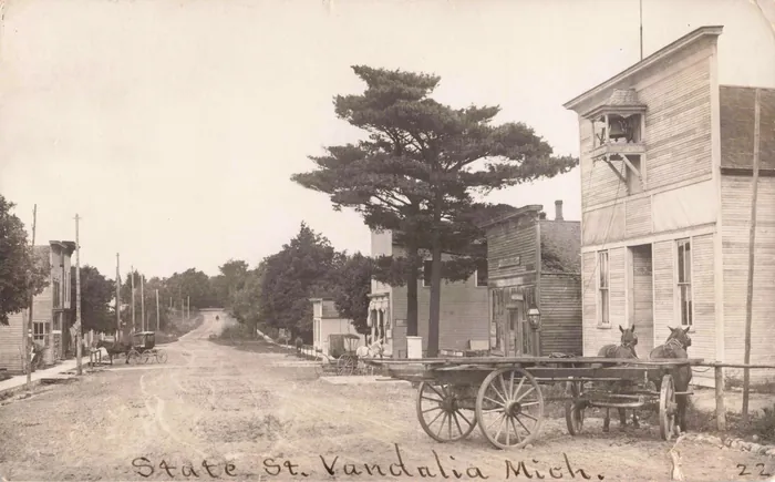
Then: State St., Vandalia, Mich, 1909. Tinder Collection, Clements Library, University of Michigan 2 Milo E. Barnes Park markers, Vandalia
State Street (M-60) at Water Street, Vandalia, MI 49095
Two markers stand a few steps apart in the village where O'Dell's mill stood: the state's 'Underground Railroad' marker (S137) of 1957, which calls Vandalia the junction of two Underground Railroad routes, and the Underground Railroad Society of Cass County's 'Kentucky Raid' marker. Near here, Rogers wrote in 1875, the raiders were surrounded by neighbors 'armed with rifles, shot-guns, straw cutters, axes, clubs.' The park is Stop 1 of the society's own Underground Railroad driving tour.
Open: Public park; markers readable any time.
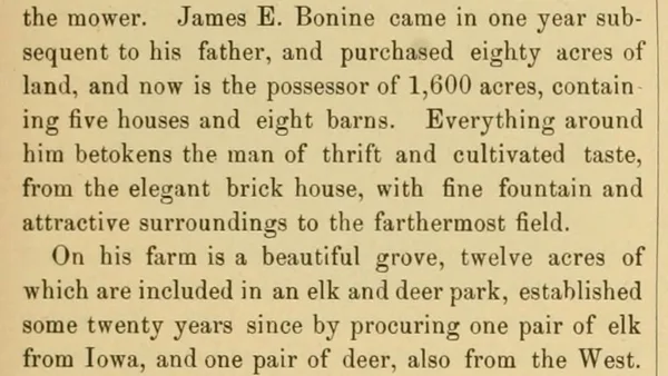
The 1882 county history on James E. Bonine: 1,600 acres, the elegant brick house with fine fountain, and the elk and deer park. 3 James E. Bonine House and carriage house
18970 M-60, Vandalia, MI 49095 (M-60 at Penn Road)
A brick house with a mansard tower and, across M-60, a small Gothic carriage house, owned since December 2010 by the Underground Railroad Society of Cass County. James E. Bonine married Sarah Ann Bogue, daughter of Stephen Bogue, whose farm the raiders struck; his farm was famous for an elk park, and the 1882 county history says elk from it were sold to the King of Italy. The tower came with a remodeling after the Civil War, and the story that freedom seekers sheltered in the carriage house is the society's tradition, not yet found in a written record.
Open: Seasonal: tours May to October, Monday to Friday, 2 to 5 p.m., and on the society's special days (Christmas, Underground Railroad Days in July); check urscc.org before you go. Grounds of the private houses nearby are not open.
4 The Bogue boulder (view from the road)
M-60 at Crooked Creek Road, southwest corner, between Vandalia and Cassopolis, MI
A boulder set in 1931 by the Woman's Club of Cassopolis: 'This boulder commemorates a station of The Underground Railway used from 1840 to 1850. It was the home of Stephen Bogue who aided runaway slaves on their way to freedom.' Rogers named Bogue's farm as one of the two Underground Railroad stations in the county, and it was one of the farms the Kentuckians raided in 1847. The suit against Bogue in federal court was dismissed in 1852.
Open: View from the road; pull off only where it is safe on M-60.
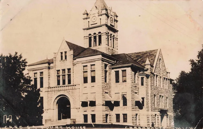
Then: Cass Co. Court House, Cassopolis, Mich, 1910. Tinder Collection, Clements Library, University of Michigan 5 Cass County Courthouse and the 'Freedom Road' marker
120 N. Broadway St., Cassopolis, MI 49031 (marker on the south side, at State Street)
The hearing of 1847 was held in Cassopolis, where a commissioner, Ebenezer McIlvain, freed all nine because no certified copy of Kentucky's slave laws was offered in evidence. The State Bar of Michigan's 'Freedom Road' legal-milestone marker (No. 30, 2005) stands by the sidewalk on the courthouse's south side. The building itself, the county's third courthouse, was completed in 1899 (state marker L487) and reopened in October 2024 after renovation as the home of county offices.
Open: Markers outdoors, readable any time; the building keeps county office hours.
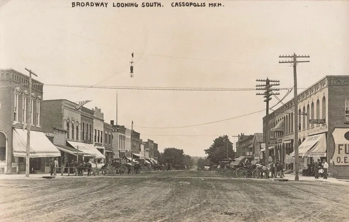
Then: Broadway Looking South, Cassopolis, Mich, 1909. Tinder Collection, Clements Library, University of Michigan 6 'Sanctuary and Deliverance' mural, downtown Cassopolis
South Broadway Street, north of West Jefferson Street, Cassopolis, MI 49031 (nearest address, per HMdb: 160 S. Broadway St.)
A downtown mural headed 'Sanctuary and Deliverance: the 1847 Kentucky raid in Cass County,' a short walk south of the courthouse. It is Stop 20 on the Underground Railroad Society's driving tour. Holden Green Tavern, nearby at 151 S. Broadway, is the place to eat on this drive.
Open: Outdoor mural, any time.
7 Dr. Nathan M. Thomas House, Schoolcraft
613 E. Cass St., Schoolcraft, MI 49087
Built in 1835 and enlarged in 1840, this was the office and home of Kalamazoo County's first physician and one of Michigan's busiest Underground Railroad stops; Pamela Brown Thomas's memoir of 1892 estimated that she and her husband helped 1,000 to 1,500 freedom seekers. The 1882 Cass County history says the Thomases fed the party of fifty-two on its way north in 1847. The house was moved to this site in 1868, belongs to the Schoolcraft Historical Society, and reopened after restoration in October 2025.
Open: Tours by event or appointment through the Schoolcraft Historical Society; otherwise view from the street. (The 1867 brick house on W. Cass Street that Thomas built later is a private home.)
8 Erastus Hussey marker and the Underground Railroad Memorial, Battle Creek
W.K. Kellogg Foundation grounds: marker on Michigan Avenue, 0.1 mile east of Capital Avenue SW (One Michigan Ave., Battle Creek, MI 49017); memorial listed at 256 W. Van Buren St., Battle Creek, MI 49017
Erastus and Sarah Hussey kept the Battle Creek station in their home and store, which stood where the Kellogg Foundation's headquarters is now; the state marker (S0637, 1992) quotes Hussey's 1885 answer to whether stationmasters were paid: 'We were working for humanity.' In 2024 the Hussey site was added to the National Park Service's Network to Freedom. Nearby, Ed Dwight's bronze memorial, 14 feet high and 28 feet long, shows Harriet Tubman leading freedom seekers and the Husseys bringing people into their house.
Open: Outdoor marker and sculpture; view any time from public walks.
9 Sojourner Truth statue, Monument Park
Monument Park, Michigan Avenue at Division Street, Battle Creek, MI 49014 (nearest address, per HMdb: 110 Michigan Ave.)
Tina Allen's 12-foot bronze of Sojourner Truth at a lectern, dedicated by the people of Battle Creek on 25 September 1999; the inscription reads 'It is for each of us who stand here to carry on the work of truth.' Truth made Battle Creek her home in her later years. Perry Sanford, who fought his way out through a cornfield on the night of the 1847 raid, also settled in Battle Creek and told his story to a local paper in 1884.
Open: Public park, any time.
Food and rest stops
Food on the way, from the site's list: Holden Green Tavern, 151 S. Broadway, Cassopolis (/food/eat/#holden-green-tavern). The list has nothing yet in Vandalia, Schoolcraft or Battle Creek. Public restrooms: none confirmed on this route; plan on the Cassopolis stop.
Before you go
- Hours change and some stops are by appointment: check each place before you set out.
- Stops marked “view from the road” are on private or working property: please stay on the road.
- Distances and times are road distances, rounded, without time spent at the stops.
Sources
- Howard S. Rogers, History of Cass County, from 1825 to 1875 (Cassopolis, 1875), pp. 129-141. Internet Archive. link
- History of Cass County, Michigan (Chicago: Waterman, Watkins & Co., 1882). Internet Archive. link
- Project Scroll, 'The Kentucky Raid of 1847' (22 October 2026). link
- Project Scroll, 'The Bonine House at Vandalia' (22 October 2026). link
- Underground Railroad Society of Cass County, UGRR Site Driving Tour. link
- Underground Railroad Society of Cass County, Chain Lake Church. link
- Historical Marker Database: The Underground Railroad (S137), Vandalia. link
- Historical Marker Database: The Kentucky Raid, Vandalia. link
- Historical Marker Database: A Station of the Underground Railway (Bogue boulder, 1931). link
- Historical Marker Database: Chain Lake Baptist Church and Cemetery (L1352). link
- Historical Marker Database: Freedom Road (Michigan Legal Milestone 30). link
- Historical Marker Database: Cass County Courthouse (L487). link
- Historical Marker Database: Sanctuary and Deliverance. link
- Watershed Voice, 'Cass County Historic Courthouse reopening after major renovation' (30 September 2024). link
- National Park Service, Dr. Nathan Thomas House. link
- South County News, 'Renovated Nathan Thomas House open Oct. 4' (10 September 2025). link
- Historical Marker Database: Erastus Hussey: Stationmaster (S0637). link
- Michigan DNR, 'Two Michigan sites added to National Underground Railroad Network to Freedom' (28 October 2024). link
- Kalamazoo Arts, public art: Underground Railroad (Ed Dwight). link
- Historical Marker Database: Sojourner Truth Statue. link
- Battle Creek Visitors, 'Take a tour of African American history in Battle Creek.' link