Near South Bend
Crumstown: The Point, the Partners and the Mastodon
A boy found an Ice Age giant on a ditch bank southwest of South Bend in 1906. The village beside it was laid out by a Holler and named for the Crums, his partners in the marsh, and for fifteen years it answered to three names at once.
By Michael Urbanski · Project Scroll · First published · Updated · 39 min read

New finding 13 new findings in this story. See what’s new ›
Crumstown, Ind. One April morning in 1906 a boy named Charles Custer was out hunting along a new drainage ditch southwest of Crumstown when he saw bones in the spoil heaped on the bank. They were not cow bones. There were ribs more than four feet long, a thigh bone that weighed thirty-five pounds, and teeth heavier than bricks. A steam dredge had torn them out of the marsh three years before, and they had been lying in the open ever since.
Within weeks the neighbors were carrying them home as curiosities, a country priest was talking them out of their souvenirs, and Notre Dame was promising to set up a mastodon in its Science Hall. To see how an Ice Age giant came to light at a crossroads village of a hundred people, start with the ground it lay in, and with a puzzle in the village’s name: the man who laid out the town was a Holler, but he named it for the Crums.
The case in brief
What the record shows
- The point was named for the Crums, a family from Ohio who lived in Indiana, then a dozen years in Michigan just over the line, and settled at the point about 1849.
- A Crum and a Holler were partners in the land along the river by 1863, twelve years before Christian Holler platted the town and named it for the family.
- The village answered to three names at once for fifteen years: the railroad said Crum’s Point, the post office Crumtown, and the people Crumstown.
- A steam dredge turned up a mastodon about 1903; a boy found the bones in 1906, a priest saved them and Notre Dame collected them.
- The boy was a Crum grandson: Charles Custer, Olive Crum’s son, born in November 1889 and sixteen that April.
- Holler married William Crum’s daughter and lived under one roof with William for at least ten years.
What it does not show, yet
- A deed naming William Crum as Holler’s partner in the land.
- Whether any of the mastodon survives at Notre Dame today.
Story or record? Play along
Here are eight things people say about Crumstown. For each, make your call: true, false, or no record either way. Then see what the paper shows.
“Crumstown is named for the Crum family.”
True
“Crumstown was named in honor of the family which he represents,” Howard wrote in 1907 of Nathaniel H. Crum.
“A Crum laid out the town.”
False
Christian Holler drew the plat on 21 April 1875. But a Crum had been his partner in the land along the river since at least 1863.
“The town was first called Crum’s Point.”
True
That is the name on the 1875 plat and on the first post office, and the railroad station kept it until 1903.
“The Crums came straight from Ohio to Indiana in 1847.”
Not quite
The census shows them in Indiana about 1834, in Bertrand Township, Michigan, by 1840, and back in Warren Township by 1850.
“The post office was renamed because its mail went to Crown Point.”
No record
An 1880 gazetteer really did confuse the two places, but no record we have found gives the reason for the change of 1888.
“For years the village had three names at once.”
True
In 1892 a shippers’ guide listed the station as Crum’s Point and the post office as Crumstown, while the official register still said Crumtown.
“A mastodon from Crumstown stands in Notre Dame’s Science Hall.”
No record
It was promised in 1906, and the bones were at Notre Dame in 1923 and 1933, but we have found no sign it was ever put together.
“The boy who found the bones was ten.”
False
A Polish report said so, but the census of 1900 and his death certificate put Charles Custer’s birth in November 1889: he was sixteen, as the English report said.
“A priest helped save the bones.”
True
Father Alexander Buechler of Terre Coupee saw some of them and started the collection for Notre Dame, buying back what he could.
A point of land in the marsh
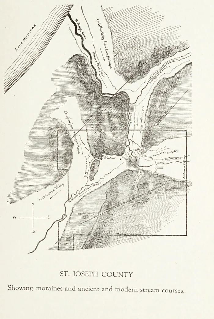
DocumentedThe name began as a description of the ground. Timothy Howard’s county history of 1907 describes “a point of land jutting out from the Michigan moraine, and now called Crum’s Point,” reaching “two miles and a half in an almost transverse direction” into the valley about seven miles below South Bend. Just below it, he wrote, lay an ancient flood plain two miles wide, drained by “a small meandering stream known as Grapevine creek, the remnant of a once mighty glacial river.”
DocumentedHoward, following the geologist Hugh T. Montgomery, believed an ice dam had once formed at the point and backed water up the valley toward South Bend, and that this helped turn the old Kankakee drainage toward the St. Joseph. Whatever the geology, the result on the ground was plain: a dry spur of farmland standing out into miles of wet prairie and marsh, close to where Grapevine Creek met the Kankakee River.
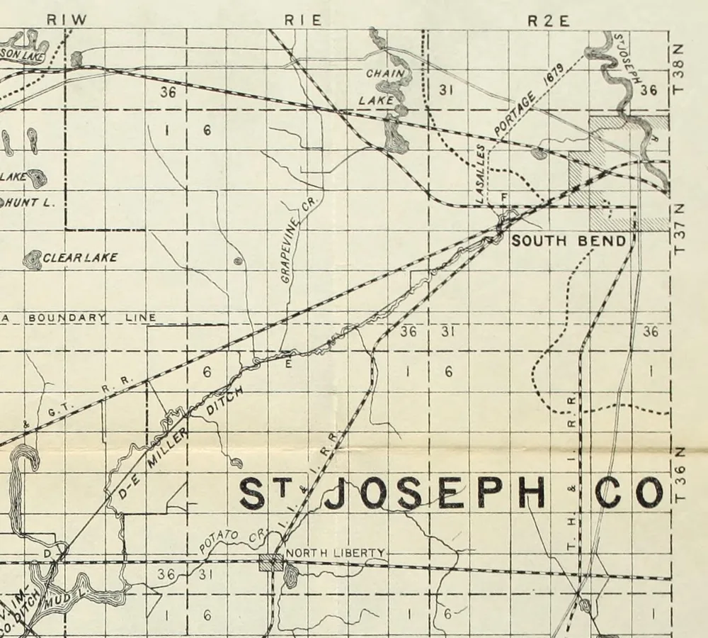
DocumentedWhen the state’s engineer, Professor John L. Campbell, surveyed the Kankakee for drainage in 1882, the Crum’s Point bridge was one of his stations; Howard reprinted the report. He gave the surface of the water there as 709.1 feet above sea level, and noted that the river at that point “begins in the open marsh and is entirely free from timber.” Two South Bend historians writing in 1899 put the junction plainly: the Grapevine, “one interminable series of crooks and turns,” forms the main part of the upper Kankakee “and is joined by the south arm at Crum’s Point.”
The Crums
DocumentedThe family who gave the point its name had its roots in Ohio. According to Howard’s sketch of Nathaniel H. Crum, his parents, Stephen Crum and Mahala (Berry) Crum, had married in Indiana, and the family came to own a farm of three hundred acres in Warren Township. The atlas of 1875 lists Stephen Crum among the Warren Township patrons: a farmer and stock raiser on Section 31, born in Ohio, in the county since 1847.
DocumentedNew findingThe census tells a longer story than the county history. Howard has the family making “the overland journey to Michigan” in 1847 and bringing Nathaniel, “but a babe,” to Indiana soon after. But in 1840 the census taker found a “Steven Crum” in Bertrand Township, Berrien County, Michigan, just across the state line from the later Crumstown, with a wife, a small son and four little girls; on the next two lines were a “John Crum,” in his sixties, and a “William Crum,” in his thirties. A county history of 1880 has a John Krum settling in Bertrand Township in 1836.
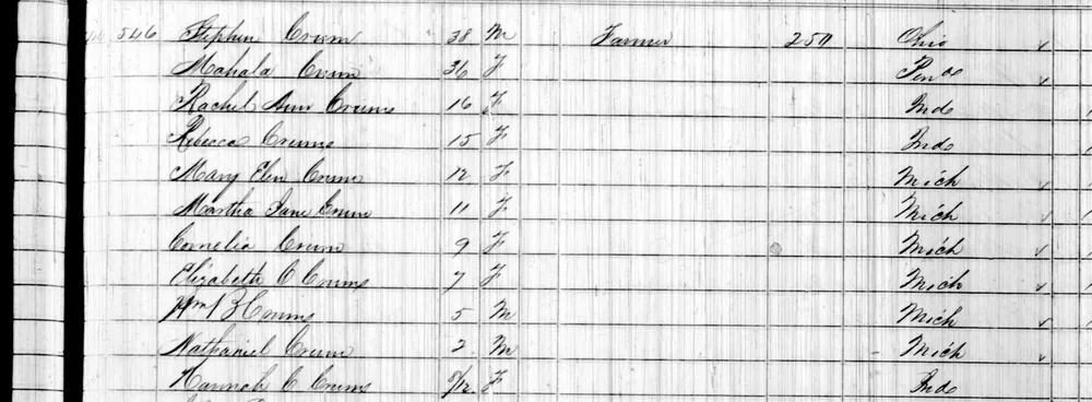
DocumentedBy 2 September 1850 the Crums were in Warren Township, Indiana. The census lists Stephen, 38, born in Ohio; Mahala, 36, born in Pennsylvania; two daughters born in Indiana about 1834 and 1835; six children born in Michigan, from Mary Ellen, 12, to Nathaniel, 2; and a baby, Hannah, born in Indiana that winter. Stephen’s brothers seem to have come too: a Peter Crum and a William Crum, both born in Ohio, lived next door.
ReadingSo the Crums were not newcomers in 1847. They had lived in Indiana, spent a dozen years farming in Michigan a few miles north, and came back to the edge of the Kankakee marsh about 1849. The point of high ground they farmed took their name.
DocumentedStephen and Mahala had fourteen children, eleven of whom grew up. Their son William served in the 12th Indiana Cavalry from 1863 to the end of the war and died on the home farm in 1907. Nathaniel married Hannah Whiting of La Porte in 1874. Howard describes him as six feet three inches tall, “a gentleman of commanding appearance,” and says that as a boy he could bring down a game bird or a squirrel with a thrown stone. In 1860 the census found the youngest daughter, Olive, three years old; she will turn up again in this story.
ReadingThe family also carried a story about Stephen’s father, John Crum, which Howard prints as family history: that John was captured as a small boy and lived with the people who took him until he was eighteen, when the head of the band told him who his parents were and where to find them, and that he then went home, married Mary Lee in Ohio, and raised four sons and two daughters. It is a family tradition, not a record, and we have not been able to test it. The John Crum of the 1840 census, a man in his sixties living beside Stephen and William, may be the same man.
DocumentedOn the town’s naming Howard is direct: “Crumstown was named in honor of the family which he represents.” Nathaniel was still living near the village in 1923, when his sister Ollie’s obituary named “one brother, Nathaniel, of Crumstown.”
Holler and Crum
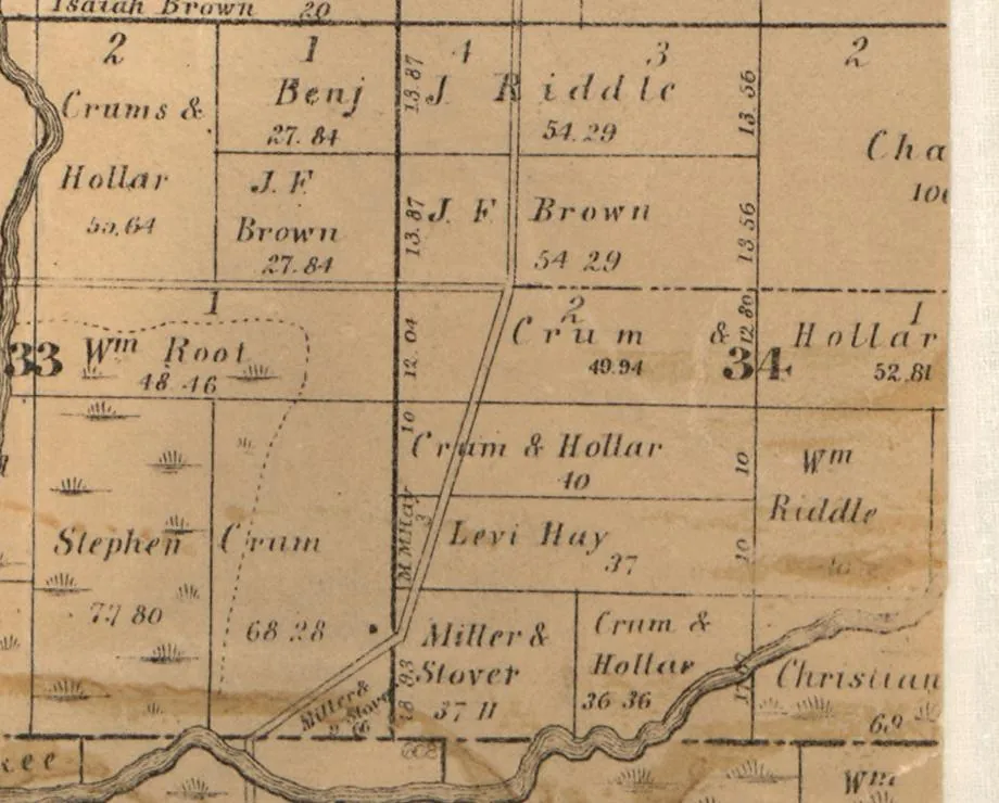
DocumentedNew findingThe county histories never mention it, but the maps show a partnership. On the county map of 1863, five tracts along the Kankakee in Sections 33, 34 and 35 of Warren Township are marked “Crum & Hollar” or “Crums & Hollar,” and right beside them lie “Stephen Crum, 77.80” acres and another Crum tract. Twelve years later, the atlas of 1875 shows the same partners, now written “Holler & Crum,” holding parcel after parcel in Sections 25, 26, 34 and 35, with other tracts beside them marked “C. Holler.”

ReadingThat map changes how the town’s name reads. The man who drew the plat was a Holler, and he named the first cross street Holler Street; the town itself he named for the Crums, his partners in the land along the river for at least twelve years. And the partners were family.
DocumentedThe county’s marriage register shows how. On 29 September 1857 the clerk issued a licence to Christian Holler and Mary E. Crum, and on “the first day of October A.D. 1857” Jacob Miller married them. Holler was the Crums’ partner and their son-in-law.
ReadingWhich Crum, then? In 1850 there were two girls of the right name and age on neighbouring farms: Stephen’s daughter Mary Ellen, 12, born in Michigan, and Mary E., 11, in William Crum’s household. Family records compiled on Find a Grave make Holler’s bride William’s daughter, Mary Elizabeth. The census settles it.
DocumentedNew findingOn 26 June 1860 the census taker came to William Crum’s farm in Warren Township and wrote down William, 50, and Ann, 42, both born in Ohio; their son James, 13; and then “Christian Holler, 24,” a farmer with $3,000 in land, more than William’s own $2,000, with “Mary E,” 21, born in Indiana, and “John,” one year old. Three households down the same page, Stephen Crum’s daughter “Mary,” 23, born in Michigan, was still living at home, unmarried. Holler’s wife was William’s Mary E.
DocumentedThe two families stayed under one roof. In 1870 the census found “Wm Crum,” 61, and “Anna Crum,” 51, living in Christian Holler’s household. In 1880 William, 71, a “retired farmer,” and Ann had a house of their own next door, and the census, which that year asked for parents’ birthplaces, gave both of Mary E. Holler’s parents as born in Ohio, as William and Ann were. Stephen’s wife, Mahala, was born in Pennsylvania.
ReadingSo the man who drew the plat and named the town for the Crums was William Crum’s son-in-law, and had shared his house for at least ten years. William is by far the likeliest partner in “Crum & Hollar.” A “retired farmer” by 1880, he fits a partnership that was over by 1887, when Holler was buying cattle on his own. “Crums,” in the plural, may still take in Stephen, whose land lay alongside. Only a deed would prove it.
DocumentedHoward records the platting. “On April 21, 1875, Christian Holler laid out the original plat of the town of Crum’s Point, on the line of the Grand Trunk railroad, in Warren township, not far from the junction of the Grapevine creek with the Kankakee river.” It lay on the southwest quarter of the southwest quarter of Section 27, and the surveyor Matthias Stover had made the survey on 7 and 8 September 1874. Holler platted an addition on 20 January 1882.
DocumentedA Holler had been in the county since the beginning. The atlas, Chapman’s history of 1880 and Howard all name a Christian Holler among the first settlers of German Township in 1830, and Chapman says he built the township’s first frame house, on Section 7. A Christian Holler of Warren Township also appears, in Howard’s history, in the lists of the county agricultural society. The man who platted the town was not the settler of 1830 but his son.
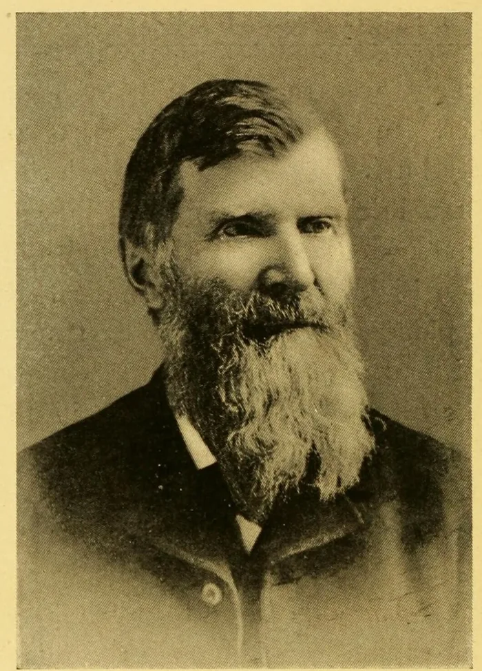
DocumentedNew findingThe town’s founder was the settler’s son. When he died at South Bend on 19 December 1902, the Indianapolis Journal’s obituary of “Christian Holler, Former Senator from St. Joseph County” said he “was a son of Christian Holler, sr.,” and had been born on 7 August 1833 “in a log cabin on Portage prairie.” He had been a justice of the peace in Warren Township for four years, its postmaster for four and its assessor for seven; he was elected to the legislature in 1882 and to the state senate in 1894. A Fort Wayne paper added a week later that he “was the largest land owner in St. Joseph county, his holdings amounting to 4,300 acres.”
DocumentedThe two families stayed close. When Holler was in the state senate, the Walkerton paper reported in January 1897 that “W. B. Crum, of Crumstown,” Stephen’s son William, “has been appointed assistant door keeper of the state senate.”
DocumentedHoller was a cattleman. The state gazetteers of the early 1880s list him at Crum’s Point under live stock, and in March 1887 the Walkerton paper reported him buying cattle “to put on his farm at Crum’s Point.” By 1896 the low land along the river was “his lands,” and the South Bend Tribune reported that Senator Holler, “who has devoted much intelligent effort to the reclamation and cultivation of Kankakee marsh lands,” had “undertaken individually” to straighten the river where its bed “bisects his lands for a distance of about three miles,” with a contractor to “keep a steam dredge in operation night and day” from Section 25 until a channel twenty feet wide was cut.
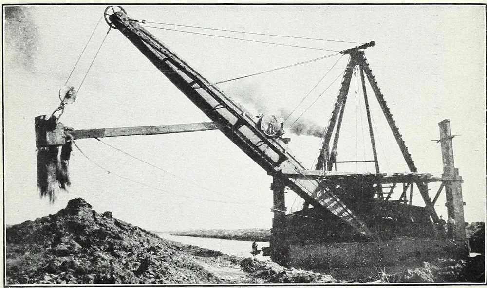
DocumentedThe point had its excitements. In November 1891 a barn full of hay belonging to Holler at Crumstown was struck by lightning and burned to the ground. A year later the same paper reported “silver ore” found on his farm while a well was being driven, “at a depth of 106 feet”; a South Bend jeweler declared that the sample contained silver, though Holler himself did not think there was enough of it “to pay for operating.” Nothing more was heard of the Crumstown silver mine.
ReadingSo the partnership seems to have ended somewhere between 1875 and 1887, with Holler keeping the land. When it began, and on what terms, the county’s deed books should say. The dredge on Holler’s river in 1896 was one of the first of the machines that would drain the marsh, and turn up the mastodon.
DocumentedThere was work at the point besides farming. The atlas marks a saw mill beside the railroad in Section 26, and Chapman’s biography of Isaac R. Cole says that Cole and his brother owned two saw-mills, “one in Liberty tp. and the other at Crum’s Point.”
DocumentedOne more name on the 1875 map is worth noting. Just west of the town, on Section 28, a tract is marked “H. Studebaker.”
OpenWhose was it? Henry Studebaker, the eldest of the wagon-making brothers, left the firm in 1858 to farm, but every account puts his farm on the south side of South Bend, miles from here. He is the only H. Studebaker we have found in the county, and the tract is on neither the map of 1863 nor the atlas of 1911. It may have been an outlying purchase of Henry’s; the deed index for Section 28 would settle it.
The plat, then and later
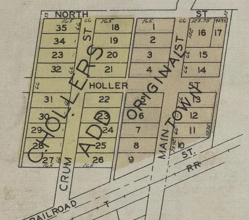
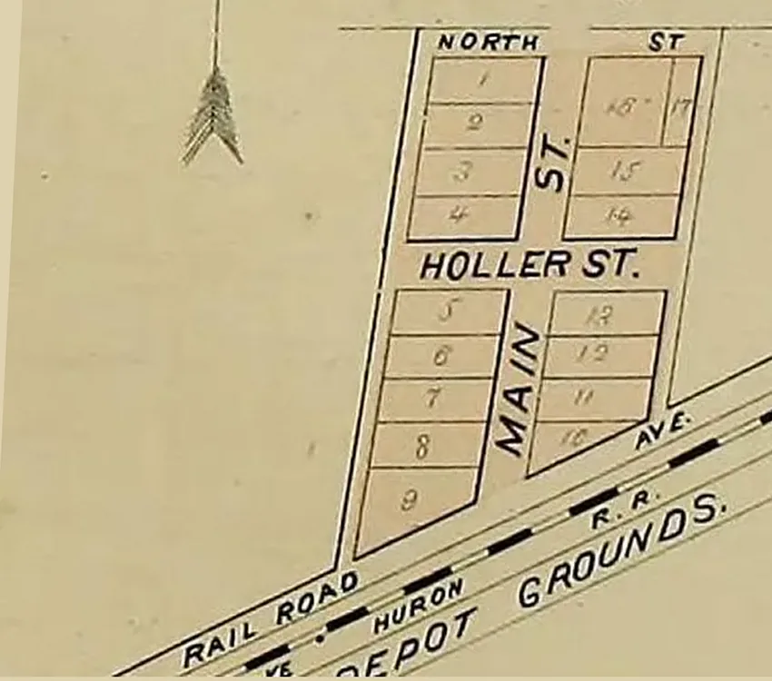
DocumentedThe first plat shows seventeen lots along Main Street and Holler Street, with “depot grounds” beside the tracks. The tracks were then those of the Chicago and Lake Huron Railroad, the line from Port Huron to the west that became part of the Grand Trunk system; the atlas marks it “Lake Huron R.R.”
DocumentedThe plat book of 1929 shows how the village had grown, which was not by much. It was by then the “Village of Crumstown,” with the Original Town on both sides of Main Street and C. Holler’s Addition to the west, and a Crum Street to go with Holler Street. Two of the old names had become streets; the third had become the town.
A duck hunter’s last day
DocumentedNew findingWithin two years of the platting, Crum’s Point was the scene of a death that South Bend did not forget. Colonel Alfred B. Wade had enlisted in the 9th Indiana, joined the 73rd Indiana as its adjutant, and come out of the war its colonel; Chapman credits him with holding the fort at Athens, Alabama, against a much larger force of Confederate cavalry in 1864. He came home to practice law. When Grant became president he was appointed South Bend’s postmaster, and he was reappointed in 1873.
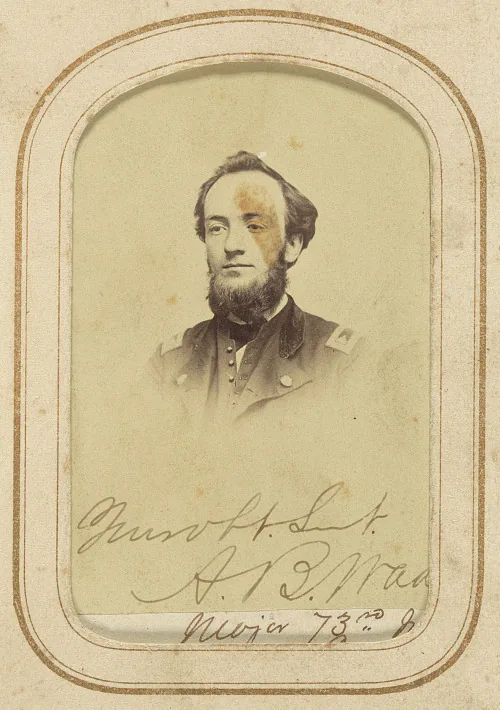
DocumentedOn Tuesday, 27 February 1877, Chapman wrote, Wade drove out of South Bend “for Crum’s Point, about ten miles distant, to hunt ducks.” He went alone, with his dog, his gun, a pail of provisions, and a light metal boat built in two sections. At the point he left his horse and wagon with Christian Holler (Chapman spells the name Haller, and so did a state gazetteer of 1880) and put his boat on the river.
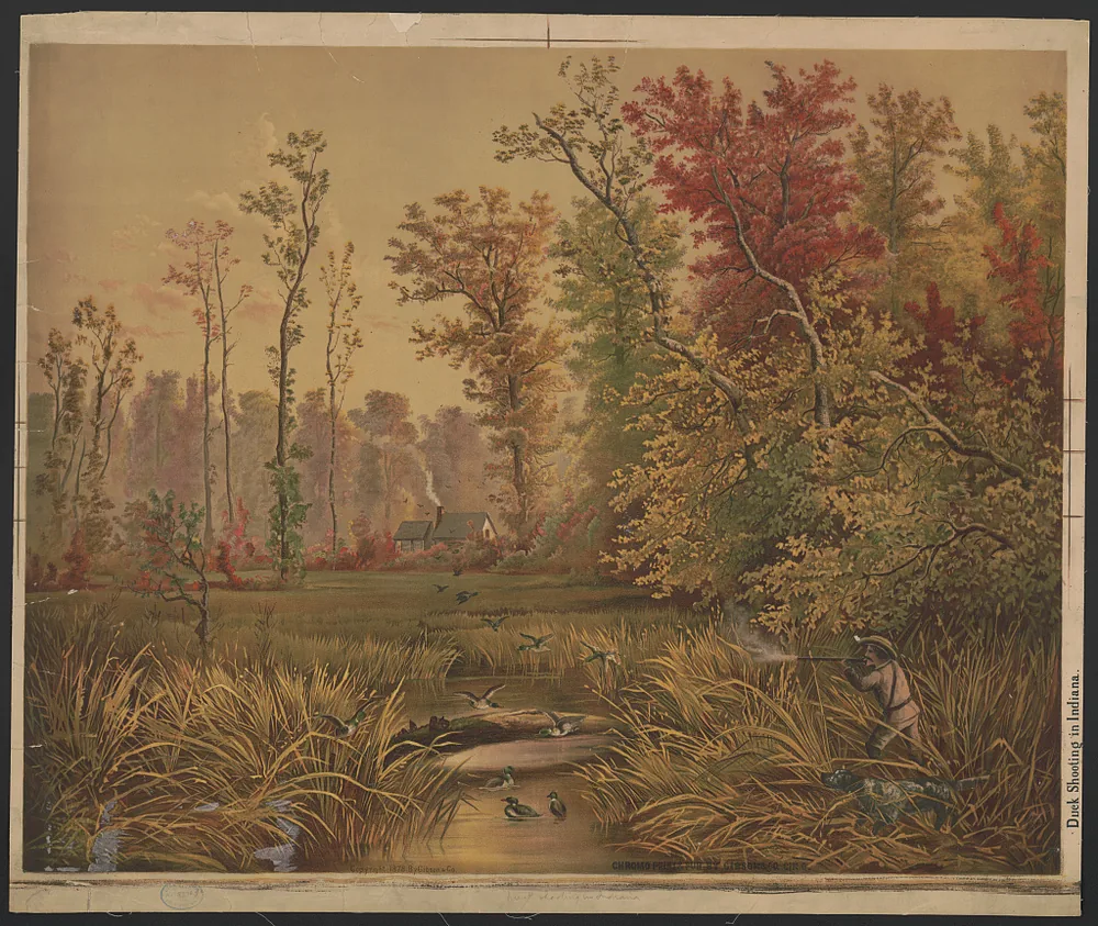
DocumentedLate that afternoon the dog came back to Holler’s alone, “but nothing strange was thought of the matter.” The next day two trappers found the empty boat lodged in the rushes downstream, with the colonel’s gun lying beside his gun case on the seat. Fifteen or twenty men searched until dark. His body was found the following morning about three-quarters of a mile above the boat. The inquest returned “accidental drowning,” and the theory was that one of the dizzy spells he had been having had tipped him into water too cold to swim in. He was thirty-seven.
Three names for one place
DocumentedThe village had its post office from the start, but it could not settle on a name. Jim Forte’s records of Indiana post offices list Crum’s Point from 1875 to 1888, Crumtown from 1888 to 1893, and Crumstown from 1893 until the office closed in 1918. A guide to Indiana place names dates the first change to 3 February 1888.
DocumentedNew findingThe confusion was real, at least on paper. In the state gazetteer of 1880–81 the entry for Crum’s Point, “a postoffice and station on the N. W. G. T. Ry, in Warren township, St. Joseph county,” goes on to place it “9 miles southwest of Crown Point, the county seat.” Crown Point is the seat of Lake County, some fifty miles away; the entry happens to follow Crown Point’s own in the alphabetical list. The editions of 1882–83 and 1884–85 correct it to “9 miles southwest of South Bend.” The same entries name the postmaster, Christian Haller, in 1880, and George Sensenbaugh by 1884, along with Cole Brothers’ saw mill, Noah Hay’s grocery and, by 1884, the general store of Samuel Custer and his brother.
DocumentedThe name had settled on the maps quickly. The state atlas of 1876 already printed “Crums Point” on its map of St. Joseph County, and the Indianapolis Journal’s pension lists catch the switch in a single man: Alexander Emberlin was “of Crum’s Point” in January 1888 and, printed “Hemberlin,” “of Crumtown” in May 1890.
DocumentedNew findingThe changes did not come with a new postmaster. The federal register lists J. H. Pontius as postmaster at “Crum’s Point” in 1887, at “Crumtown” in 1889, 1891 and 1893, and at “Crumstown” in 1895. Nor did one name replace another everywhere at once. The Post Office’s own guide of January 1889 lists the office as “Crumtown” in its list by states and as “Crumstown” in its alphabetical list. A shippers’ guide of 1892 lists “Crum’s Point” as the railroad station, “(Crumstown P O),” and “Crumstown” as the post office, “(RR name Crum’s Point).” The register still said Crumtown in July 1893; by December the postal guide said Crumstown. The telegraph office kept the old name ten years longer, until a notice of October 1903: “Crum’s Point, changed to Crumstown.”
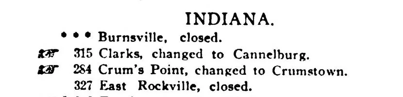
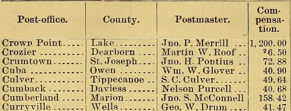
DocumentedNew findingThe people’s name was in print within months of the change. On 25 August 1888, six months after the post office became Crumtown, the Walkerton paper reported that “an old fashioned reunion was held at the residence of Josh Brown, near Crumstown, last Sunday.” The next June it wrote up a ball game between “the Crumstown boys” and the Walkerton “Swipers,” stopped after the second inning on account of rain. Through the five years when the official name was Crumtown, the county paper said Crumstown.
ReadingSo for fifteen years the place answered to three names at once: Crum’s Point to the railroad, Crumtown to the post office, and Crumstown to the people who lived there. The change of 1893 looks less like a renaming than the Post Office catching up. It fits the rule the new federal Board on Geographic Names announced in 1892, that “the name which is in common local use at present should be adopted.” Why the post office had turned Crum’s Point into Crumtown in 1888 is still unknown. A local writer, Loren Shaum, has suggested it was to stop the mail going astray to Crown Point, which fits the dates and the Department’s dislike of names that looked alike on an envelope; it is a good guess, but only a guess.
DocumentedIn 1907 Howard used both names: “Crum’s Point, or Crum’s Town, as it is frequently called.” He gave the population in 1900 as one hundred, and predicted that with the drainage of the upper Kankakee valley the place “is quite likely to grow to be a place of considerable importance.”
Farms after the drainage
DocumentedHoward’s prediction rested on the draining of the marsh, and the farms around the village bear it out. James W. Ryder worked thirty years as a foreman for the Grand Trunk before turning to his 185-acre farm half a mile from the town; Alexander Riddle and his wife lived on a hundred acres adjoining it; and Joshua F. Brown, who had gone overland to California in 1849, came back to spend the rest of his life on a farm at Crumstown. Not every acre was dry: Newton W. Walters’s fifty acres near Lydick had “a large huckleberry marsh” on them.
DocumentedFaith came with the farmers. Howard credits a Mennonite minister named Yoder, who came to Warren Township in 1865 and preached for forty years, with founding a church of that denomination at Crumstown, and lists two Civil War soldiers, John M. Guyse and James M. Neidhardt, among the veterans buried in the Crumstown Cemetery.
DocumentedFarmers in the Kankakee section were still asking for roads in 1915. That summer a petition circulated among landowners for a new road to connect with the Laporte road southwest of Crumstown and give the land between the Division Street and Crumstown road and the Sumption Prairie road “direct outlet”; part of it would run down the Grand Trunk tracks or “the Kankakee ditch bank” to Crumstown. In 1920 farmers met at Crumstown to consider building a cooperative grain elevator there.
The mastodon in the sand
DocumentedNew findingIn 1906 newspapers from Indiana to New Jersey and New Mexico carried a short item from Notre Dame, first in July and again that November. Professor A. B. Reynolds of the university, it said, “has finished collecting the bones of a mastodon which was unearthed by a steam dredge on the farm of George Larkowski, three miles southwest of Crumstown.” The skeleton was to be set up in Science Hall.
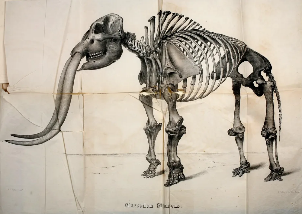
DocumentedThe Plymouth Tribune’s fuller version tells how the bones were found. The dredge cutting a big ditch through the marsh had turned them out about 1903, and had itself stuck fast at the spot for four days. Then, “while hunting in April, Charles Custer, a boy of sixteen, discovered a number of great bones and teeth lying on the bank of a large ditch.” Neighbors came to look and carried bones home as relics. A priest of Terre Coupee, the Rev. Alexander Buechler , saw some of them and started the collection for the Notre Dame Museum. “Many who had taken bones, willingly gave them up, while others insisted on securing a price for them.” The skeleton had lain in quicksand under nearly eight feet of decayed marsh hay; the skull, tusks and hips were broken by the dredge, but most of the vertebrae, ribs and leg bones were sound, and the missing bones were to be made up in plaster of Paris.
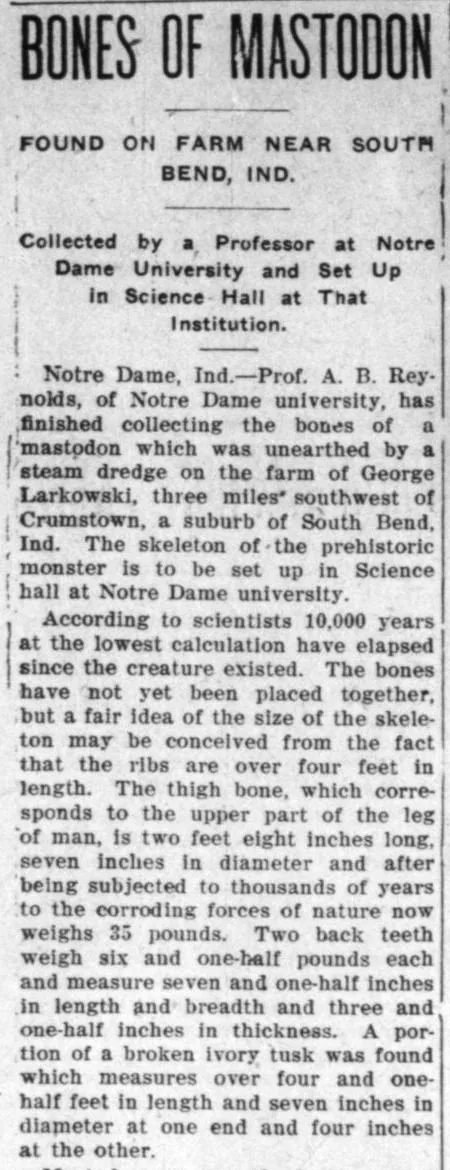
DocumentedThe fullest version of the story, syndicated that November, adds the measurements and the scene. The skeleton lay in quicksand at least a quarter of a mile inside the marsh, under nearly eight feet of decayed marsh hay; the dredge had mired at the spot and taken four days to get out. The two back teeth weighed six and a half pounds each and measured seven and a half inches long and broad. And despite its headline, the story admitted that “the bones have not yet been placed together.”
DocumentedChicago’s Polish daily, Dziennik Chicagoski, carried the story the same day, with two differences: it made Charles Custer a boy of ten who found the bones three years earlier, and it spelled the farmer both Laskowski and Larkowski. The English report, which puts the find in April of that year, is the more detailed of the two.
DocumentedNew findingThe priest who saved the bones was the Rev. Alexander A. Buechler, pastor of St. Stanislaus’ church at Terre Coupee, near New Carlisle, from 1 May 1901. The diocesan history of 1907 says he was born at Ottawa, Illinois, on 12 March 1877, grew up at Otis, Indiana, and was ordained in 1900; in his years at Terre Coupee the parish built the church it dedicated in 1906, the year of the mastodon. Howard calls him “one of the best known and most generally loved citizens of Olive township,” the owner of a library of a thousand books.
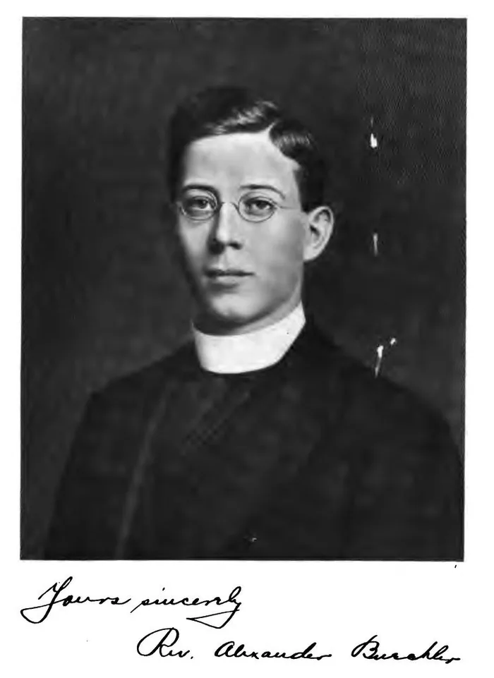
DocumentedHe was a man of wide interests. In 1903 the Indianapolis Journal listed him on the board of directors of a South Bend company formed to make bullet-proof cloth, invented by Casimir Zeglen; in a test in South Bend, a police sergeant had fired five shots from a .44 revolver into the cloth at six paces, “but did not penetrate it.” In 1909 he moved to St. Mary’s church at Otis.
DocumentedThe professor in the story was not a scientist. The Catholic directory of 1906 lists A. B. Reynolds among the Notre Dame faculty as an “instructor in English and Latin”; Alphaeus B. Reynolds had published a Latin grammar for beginners in 1902.
DocumentedNew findingThe boy was a grandson of Stephen Crum. Olive Crum, the three-year-old of the 1860 census, married John Custer on 15 November 1877, and their son Charles Melvin Custer was born on 20 November 1889. Three records agree on him. The census of 1900 found him, eleven, born in November 1889, with his parents John and Ollive and five brothers and sisters at Knox, in Starke County; when he enrolled for war service at South Bend in July 1917 he gave his birthplace as Crumstown; and his Michigan death certificate of 1938 gives his birth date and names his mother as Allie Crum. In April 1906 he was sixteen, as the English report said, not ten.
DocumentedIn 1910 he was living with his mother in South Bend, and when she died at Decatur, Michigan, in 1923 her obituary named him among the sons at home, with her brother Nathaniel of Crumstown, and she was buried at Crumstown. The mastodon was found by one of the family that gave the village its name.
ReadingWhat became of the skeleton is still an open question, but it did reach Notre Dame.
DocumentedNew findingIn 1923 the paleontologist Oliver P. Hay, listing every mastodon find he knew of in Indiana, recorded that “in the museum at Notre Dame University are considerable remains of a mastodon, found about 1902 in Olive Township, about 12 miles west or southwest of Notre Dame.” A 1933 survey of the county’s mammals still credited the specimens to the university.
DocumentedTen years later there were two. A survey of the county’s mammals in 1933 recorded the American mastodon from Hay’s two Notre Dame entries and gave the count as “2: U.N.D.,” two specimens at the University of Notre Dame. When Marcus Ward Lyon Jr. surveyed the mammals of all Indiana in 1936, he could cite only those two records for the county.
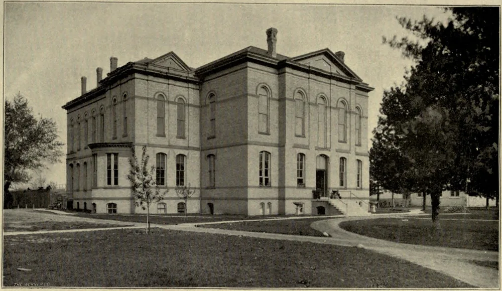
ReadingHay’s date and township may be a little off, but a find of about 1902, west or southwest of Notre Dame and kept in its museum, points to the Crumstown mastodon. We have found no record that the skeleton was ever set up in Science Hall. The old Science Hall museum’s fossils passed in 2012 to the university’s Museum of Biodiversity, so that is where any surviving bones should be.
Polish neighbors
DocumentedThe farm in the mastodon story was one of many Polish farms around the village by the turn of the century, and the best record of them is in their own language. Polish weeklies and dailies from Toledo to Chicago and Winona, Minnesota, carried news of the Kankakee farms that the English papers rarely noticed.
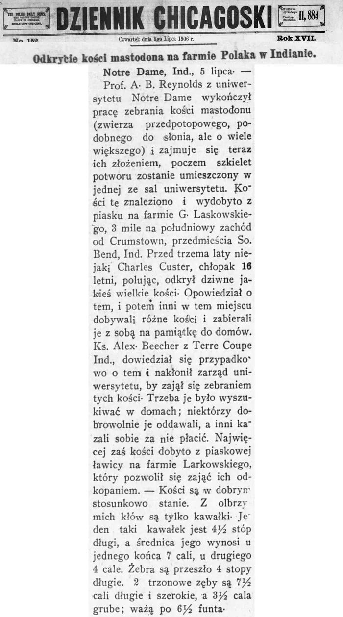
DocumentedThe farm in the mastodon story was one of a number of Polish farms around the village by the turn of the century. In March 1900 the Toledo Polish weekly Ameryka reported that Wincenty Laskowski, living a mile east of Crumstown, had been struck by a passenger train while crossing the tracks with a hay wagon. In 1901 a Polish teacher, Józef A. Werwiński, took up the post again at the public school in Crumstown. In May 1914 the Winona Wiarus reported the death in Crumstown of Józef Laskowski, aged 105, born in Poland, who had fought in three European wars.
DocumentedThe South Bend papers of the 1910s and 1920s are full of these names. The Crumstown indoor ball team of 1927 had a battery of Szawark and Jerzak, and Mrs. Tekla Chrzan died in 1914 at her daughter’s home in “Crums Point,” the old name still in use.
DocumentedNew findingThe census points to the farmer. In 1900 and again in 1910 the census taker for Olive Township, the township Hay named, found George Laskowski, a farmer born in Polish Germany in 1855, who had come to America in 1868, living there with his wife, Mary, and their children. No Larkowski appears. The Polish paper’s Laskowski was the right spelling.
ReadingThe farm where the bones lay was very probably his. The English report put it three miles southwest of Crumstown and Hay put it in Olive Township; a plat book of the time, showing where the Laskowski land lay, would fix the spot.
Missionaries in 1896
DocumentedNew findingIn the autumn of 1896 the little village was briefly a meeting place for missionaries of the Church of Jesus Christ of Latter-day Saints. A young elder, writing home from Muncie on 29 November, told readers of the Deseret Evening News in Salt Lake City that he and his companion had worked through the summer in St. Joseph and La Porte counties.
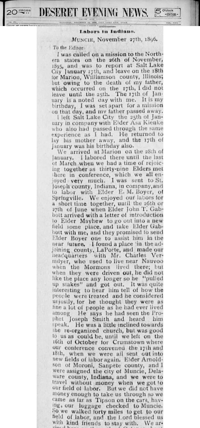
DocumentedThey had made their headquarters with a La Porte County man who had once lived near Nauvoo, Illinois. On 16 October they left “for Crumstown, where our conference convened the 17th and 18th,” and at its end the elders were all sent out to new fields. The writer and his partner drew Muncie, and walked the last forty miles to it, arriving with one cent between them.
ReadingThe letter does not say why a conference of traveling elders met at Crumstown rather than in South Bend. A crossroads village on a railroad, with friendly farm families around it, would have been an easy and inexpensive place to gather.
A village of its own
DocumentedCrumstown was small, but it was a place. In March 1914 two men broke into Charles Beringer’s grocery in the middle of the night; burglar alarms woke the grocer at his house, and he and his son caught them, the father guarding the front door and the son the back. The village had a ball team that took on Mill Creek, Tyner and the clubs of South Bend: in 1915 it beat Mill Creek 4 to 3 at home, and in 1928 it won a ten-inning game against Tyner 1 to 0, losing its catcher to a broken finger in the first inning. In the autumn of 1914 a revival was held at Crumstown, with an outdoor service led by laymen from South Bend, and in 1921 the church directory listed a Crumstown Union church, interdenominational, with a Bible school on Sunday mornings.
DocumentedThe railroad that made the village could also take from it. On the morning of 29 December 1916 a westbound Grand Trunk freight struck a buggy at the Main Street crossing. Alta Day, nineteen, was killed instantly, and her companion Helena Fox died that afternoon in a South Bend hospital. Witnesses disagreed about whether the whistle had sounded; a building beside the track had blocked the young women’s view.
DocumentedThe school was the village’s pride. In 1919 four of the graduates at the joint Warren and German township commencement came from the Crumstown school, and two of them, Charles Day and Harriet Shone, received honors. In September 1930 the county superintendent announced that a new four-room school at Crumstown was finished, with 140 pupils enrolled in grades one through eight.
Crumstown today

DocumentedCrumstown is still on the map, an unincorporated community in Warren Township. The post office closed in 1918, and the village now shares North Liberty’s ZIP code. The road Howard lists among the main roads leading southwest out of South Bend, to Crum’s Point, was being called “the Crums Point or Crumstown Road” in a legal notice of 1924; on South Bend’s west side it is the Crumstown Highway today.
ReadingWhat survives of the 1875 town is mostly its shape. The streets Christian Holler drew beside the railroad, Main and Holler and North, are still there, and Crum Street beside them: the partners side by side on the map once more. The marsh is drained, the post office long gone, and the point of land that gave the place its first name is easy to miss from a car. But the family name has outlasted every other change.
Three questions are still open, and each has an answer somewhere in a courthouse, an archive or a family album. If you can help, write to us: we will credit you on this page.
The name on paper
Play the names in order, from the point to the village.
- 1863 Crums & Hollar (the partners, on the county map)
- 1875 Crum’s Point (the plat and the post office)
- 1888 Crumtown (the post office)
- 1889 Crumstown (the postal guide’s alphabetical list)
- 1892 Crum’s Point (the railroad station)
- 1893 Crumstown (the post office)
- 1903 Crumstown (the telegraph office, at last)
- 1907 Crum’s Point, or Crum’s Town (Howard)
- 1929 Village of Crumstown (the plat book)
A timeline
- c. 1834 Stephen and Mahala Crum’s eldest children born in Indiana
- 1840 Steven, John and William Crum in Bertrand Township, Berrien County, Michigan
- 1850 The Crums in Warren Township, Indiana, 2 September
- 1857 Christian Holler marries Mary E. Crum, William Crum’s daughter, 1 October
- 1860 The Hollers live in William Crum’s household
- 1863 “Crum & Hollar” tracts along the Kankakee on the county map
- 1874 County surveyor Matthias Stover surveys the town site, 7–8 September
- 1875 Christian Holler records the plat of Crum’s Point, 21 April; the post office opens
- 1877 Col. Alfred B. Wade drowns while hunting ducks from Crum’s Point, 27 February
- 1880 A state gazetteer places Crum’s Point “southwest of Crown Point”
- 1882 Holler records an addition to the town, 20 January
- 1887 Holler buying cattle for “his farm at Crum’s Point”
- 1888 The post office becomes Crumtown, 3 February
- 1893 The post office becomes Crumstown, between July and December
- 1896 Senator Holler has three miles of the Kankakee straightened; Latter-day Saint missionaries meet at Crumstown, 17–18 October
- 1902 Christian Holler, the town’s founder, dies at South Bend, 19 December
- 1903 A steam dredge turns up mastodon bones three miles southwest; the telegraph office drops “Crum’s Point”
- 1888 The Walkerton paper writes “Crumstown,” 25 August
- 1889 Charles Melvin Custer, Olive Crum’s son, born 20 November
- 1906 Charles Custer, sixteen, finds the bones in April; Father Buechler and Notre Dame collect them
- 1916 Two young women killed at the Main Street crossing, 29 December
- 1918 The post office closes
- 1930 A new four-room school opens with 140 pupils
If you go
DocumentedCrumstown lies southwest of South Bend, where the old Grand Trunk line, now Canadian National, crosses the road from South Bend. The streets of the 1875 plat are public, and the country around them shows the low, flat ground the drainage made. The homes in the village are private; please enjoy them from the road.
Sources
- Timothy Edward Howard, A History of St. Joseph County, Indiana, vol. 1 (Chicago: Lewis Publishing Co., 1907): Crum’s Point and the ice gorge, pp. 13–14; John L. Campbell’s Kankakee survey of 1882, pp. 245–252; the agricultural society, pp. 269–271; Warren Township, pp. 283–284; Crum’s Point platted, p. 310. Internet Archive.
- Howard, A History of St. Joseph County, Indiana, vol. 2 (1907): soldiers buried in the Crumstown Cemetery, pp. 735–736; Elmer E. Yoder (his father’s Mennonite church at Crumstown), p. 1035; Nathaniel H. Crum, p. 1050; Newton W. Walters, pp. 1052–1053; James W. Ryder, p. 1053; Alexander Riddle, pp. 1057–1058; Joshua F. Brown, p. 1064. Internet Archive.
- Charles C. Chapman & Co., History of St. Joseph County, Indiana (Chicago, 1880): Col. Alfred B. Wade, pp. 493–495; Isaac R. Cole’s saw-mill at Crum’s Point, pp. 724–725; first settlers of German Township, pp. 683–684. Internet Archive.
- Higgins, Belden & Co., An Illustrated Historical Atlas of St. Joseph Co., Indiana (Chicago, 1875): Warren Township and the plat of Crum’s Point, pp. 40–41; patrons’ directory, Warren Township (Stephen Crum). Allen County Public Library, Internet Archive.
- Atlas and Plat Book of St. Joseph County, Indiana (Rockford, Ill.: The Thrift Press, 1929), p. 60, Village of Crumstown. Library of Congress, Geography and Map Division.
- Map of St. Joseph County, in Illustrated Historical Atlas of the State of Indiana (Chicago: Baskin, Forster & Co., 1876), p. 29, showing “Crums Point.” David Rumsey Map Collection, via the Internet Archive.
- Jim Forte Postal History, post offices of St. Joseph County, Indiana (Crum’s Point, Crumtown, Crumstown).
- “Crumstown, Indiana,” Wikipedia.
- Loren Shaum, “Ever heard of Crumstown?”, Goshen News.
- Letter from an elder of the Northern States Mission, Muncie, Ind., 29 November 1896, Deseret Evening News (Salt Lake City), 12 December 1896, p. 19. Library of Congress, Chronicling America.
- “Mastadon Uncovered,” Plymouth Tribune (Plymouth, Ind.), 5 July 1906, p. 4. Chronicling America.
- “The Bones of a Mastodon,” Chickasha Daily Express (Chickasha, Indian Territory), 7 November 1906, p. 3. Chronicling America.
- Dziennik Chicagoski (Chicago), 5 July 1906, p. 1, report from Notre Dame on the mastodon bones (in Polish). Chronicling America.
- Ameryka (Toledo, Ohio), 31 March 1900, p. 4, Wincenty Laskowski struck by a train near Crumstown (in Polish). Chronicling America.
- Dziennik Chicagoski, 28 September 1901, p. 5, Józef A. Werwiński takes the school at Crumstown (in Polish). Chronicling America.
- Wiarus (Winona, Minn.), 14 May 1914, p. 5, death of Józef Laskowski at Crumstown, aged 105 (in Polish). Chronicling America.
- “Two Men Are Trapped in Crumstown Store,” South Bend News-Times, 4 March 1914, p. 12. Chronicling America.
- “Hold Out-door Service,” South Bend News-Times, 7 October 1914, p. 12; Tekla Chrzan obituary, 9 January 1914, p. 4. Chronicling America.
- “Crumstown Takes Game,” South Bend News-Times, 14 June 1915, p. 4; “Crumstown Catcher Hurt,” 27 June 1928, p. 16; Crumstown indoor team, 22 June 1927, p. 13. Chronicling America.
- Road petition in the Kankakee section, South Bend News-Times, 31 July 1915, p. 7. Chronicling America.
- “Mrs. Lena Fox Passes Away Five Hours After Death of Companion,” South Bend News-Times, 30 December 1916, p. 3. Chronicling America.
- Crumstown news (Warren Township commencement), South Bend News-Times, 28 May 1919, p. 8. Chronicling America.
- Cooperative elevator meeting at Crumstown, South Bend News-Times, 26 February 1920, p. 3. Chronicling America.
- Church directory (Crumstown Union), South Bend News-Times, 29 May 1921, p. 29. Chronicling America.
- Mrs. Ollie Custer obituary (died at Decatur, Mich.; sons Clarence, Gilbert and Charles), South Bend News-Times, 12 February 1923, p. 2. Chronicling America.
- “New Crumstown School Is Open,” South Bend News-Times, 7 September 1930, p. 4. Chronicling America.
- “History,” Museum of Biodiversity, University of Notre Dame (the museum in the Science Building, 1884–1952).
- Legal notice (the Crums Point or Crumstown Road), South Bend News-Times, 2 February 1924, p. 19. Chronicling America.
- “Crumstown Highway bridge to close on Monday,” ABC57, 5 July 2019.
- “Christian Holler, Former Senator from St. Joseph County,” Indianapolis Journal, 20 December 1902, p. 6. Chronicling America.
- State news (Christian Holler’s 4,300 acres), Fort Wayne Sentinel, 26 December 1902. Internet Archive.
- R. L. Polk & Co., Indiana State Gazetteer and Business Directory, 1880–81, vol. 1, “Crum’s Point.” Internet Archive.
- Polk’s Indiana State Gazetteer and Business Directory, 1882–83, “Crum’s Point.” Internet Archive.
- Polk’s Indiana State Gazetteer and Business Directory, 1884–85, “Crum’s Point” (George Sensenbaugh, postmaster; Custer Samuel & Bro). Internet Archive.
- United States Official Postal Guide (1894), “Crumstown.” Internet Archive.
- Oliver P. Hay, The Pleistocene of North America and Its Vertebrated Animals from the States East of the Mississippi River (Washington: Carnegie Institution, 1923), p. 100, Indiana localities 46–47. Internet Archive.
- William L. Engels, “Notes on the Mammals of St. Joseph County, Indiana,” American Midland Naturalist 14, no. 1 (January 1933). Internet Archive.
- Marcus Ward Lyon Jr., “Mammals of Indiana,” American Midland Naturalist 17, no. 1 (January 1936), pp. 339–341. Internet Archive.
- Charles H. Bartlett and Richard H. Lyon, La Salle in the Valley of the St. Joseph: An Historical Fragment (South Bend: Tribune Printing Co., 1899), p. 55 (the Grapevine at Crum’s Point) and the plate “Crumstown Trail, near the St. Joseph,” photograph by W. B. Stover. Internet Archive.
- Crum’s Point and Crumtown in Indiana pension lists, Indianapolis Journal, 24 January 1888, p. 1, and 18 May 1890, p. 7. Chronicling America.
- M. W. Stokes, Map of St. Joseph Co., Indiana ([Philadelphia], 1863), engraved and printed by Chas. Shober: “Crum & Hollar” and “Crums & Hollar” tracts in Warren Township. Library of Congress, Geography and Map Division.
- United States Census, 1840, Bertrand Township, Berrien County, Michigan, p. 20 (Steven, John and William Crum). National Archives microfilm M704, roll 203. Internet Archive.
- United States Census, 1850, Warren Township, St. Joseph County, Indiana, pp. 76–77 (William Crum, with Ann, 32, and Mary E., 11; Stephen Crum, dwelling 546). National Archives microfilm M432, roll 171. Internet Archive.
- United States Census, 1860, Warren Township, St. Joseph County, Indiana, pp. 94–95, enumerated 26 June 1860 (William Crum, with Christian and Mary E. Holler; Stephen Crum, with Mary, 23, born Michigan, and Olive, 3). National Archives microfilm M653, roll 295. Internet Archive.
- History of Berrien and Van Buren Counties, Michigan (Philadelphia: D. W. Ensign & Co., 1880), p. 229, Bertrand Township (“John Krum located on section 17 in 1836”). Internet Archive.
- Official Register of the United States, 1 July 1887, vol. 2, p. 471; 1 July 1889, vol. 2, p. 528; 1 July 1893, vol. 2, p. 578; 1 July 1895, vol. 2, p. 97 (postmasters at Crum’s Point, Crumtown and Crumstown). Internet Archive.
- United States Official Postal Guide, January 1889, pp. 55, 283 and 485 (Crumstown and Crumtown). Allen County Public Library copy, Internet Archive.
- Bullinger’s Postal and Shippers Guide, January 1892, p. 257 (Crum’s Point, “Crumstown P O”). Internet Archive.
- Journal of the Telegraph, 20 October 1903, p. 138 (“Crum’s Point, changed to Crumstown”). Internet Archive.
- First Report of the United States Board on Geographic Names, 1890–1891 (Washington, 1892), pp. 5–6. Internet Archive.
- Ronald L. Baker and Marvin Carmony, From Needmore to Prosperity: Hoosier Place Names in Folklore and History (Bloomington: Indiana University Press, 1995), “Crumstown.” Internet Archive (lending copy).
- “Bones of Mastodon Found on Farm near South Bend, Ind.,” The Washington Bee, 10 November 1906, p. 2 (syndicated; also 17 and 24 November, 1 and 8 December). Internet Archive.
- H. J. Alerding, The Diocese of Fort Wayne, 1857–September 1907 (Fort Wayne, 1907), p. 86 (the Rev. Alexander Buechler) and pp. 369–370 (Terre Coupee). Internet Archive.
- Howard, A History of St. Joseph County, Indiana, vol. 2 (1907), pp. 900–901, the Rev. Father Alexander A. Buechler, with portrait. Internet Archive.
- The Official Catholic Directory (Milwaukee: M. H. Wiltzius, 1906), Diocese of Fort Wayne: Terre Coupee, Rev. A. Buechler; Notre Dame faculty, A. B. Reynolds (instructor in English and Latin). Internet Archive.
- The Notre Dame Scholastic, vol. 35, no. 29 (26 April 1902), p. 481 (The Rudiments of Latin, by Alphaeus B. Reynolds). University of Notre Dame Archives.
- Indianapolis Journal, 14 November 1903, p. 5 (the bullet-proof cloth company; the Rev. Alexander Buechler a director). Chronicling America.
- Lake County Times (Hammond, Ind.), 6 March 1909, p. 1 (Buechler appointed pastor at Otis). Chronicling America.
- St. Joseph County Independent (Walkerton), 12 March 1887, p. 2 (Holler buying cattle for his farm at Crum’s Point). Hoosier State Chronicles.
- St. Joseph County Independent, 14 November 1891, p. 1 (Holler’s barn struck by lightning). Hoosier State Chronicles.
- St. Joseph County Independent, 26 November 1892, p. 1 (silver ore on Holler’s farm). Hoosier State Chronicles.
- “Several Miles of the Kankakee Bed to be Straightened,” St. Joseph County Independent, 4 April 1896, p. 1, from the South Bend Tribune. Hoosier State Chronicles.
- St. Joseph County Independent, 16 January 1897, p. 5 (W. B. Crum, assistant doorkeeper of the state senate). Hoosier State Chronicles.
- Find a Grave memorials (compiled by volunteers): Christian Holler (11808620), Mary Elizabeth (Crum) Holler (11808650), William Crum (11778238), Stephen Crum (11778222).
- Hugh T. Montgomery, The Geological History of St. Joseph County, Indiana (South Bend: Northern Indiana Historical Society, rev. ed., 1929), pp. 13–15 (Crum’s Point and the ice dam). Internet Archive.
- U.S. Department of Agriculture, Office of Experiment Stations, Report upon Drainage of the Kankakee River Valley, Circular 80 (Washington, 1909), fig. 1 and pp. 5–7. Internet Archive.
- Albert R. Erskine, History of the Studebaker Corporation (Chicago: Poole Bros., 1918), p. 14 (portrait of Henry Studebaker). Internet Archive.
- Alfred B. Wade, Major, 73rd Indiana Infantry (carte de visite, 1862–65). Liljenquist Family Collection, Library of Congress.
- “Duck Shooting in Indiana” (chromolithograph, Cincinnati: Gibson & Co., c. 1878). Library of Congress, Prints and Photographs Division.
- D. L. Yarnell, Excavating Machinery Used in Land Drainage, U.S. Department of Agriculture Bulletin 300 (Washington, 1915), plate I. Internet Archive.
- John C. Warren, The Mastodon Giganteus of North America (Boston, 1852), plate (the Warren mastodon). Internet Archive.
- A Brief History of the University of Notre Dame du Lac, Indiana, 1842–1892 (Chicago: Werner Co., 1895), plate facing p. 182 (Science Hall). Internet Archive.
- St. Joseph County, Indiana, Marriage Records, p. 194: Christian Holler and Mary E. Crum, licence 29 September 1857, married 1 October 1857 by Jacob Miller. “Indiana, Marriages, 1811–2019,” FamilySearch.
- United States Census, 1900, Knox, Center Township, Starke County, Indiana, ED 142, sheet 4A, household 80 (John and Ollive Custer; Charles M., born November 1889). “United States, Census, 1900,” FamilySearch.
- United States Census, 1910, South Bend Ward 2, St. Joseph County, Indiana (Charles Custer, 20, with his mother, Ollie). “United States, Census, 1910,” FamilySearch.
- Indiana World War I enrollment card, Charles M. Custer, South Bend, 25 July 1917 (born Crumstown). “Indiana, World War I, Enrollment Cards, 1917,” FamilySearch.
- Michigan death certificate, Charles Melvin Custer, Wayne Township, Cass County, 3 June 1938 (born 20 November 1889; mother Allie Crum, father John Custer). “Michigan, Death Certificates, 1921–1952,” FamilySearch.
- United States Census, 1870, Warren Township, St. Joseph County, Indiana, p. 16, household 121 (Christian Holler, with Wm and Anna Crum). “United States, Census, 1870,” FamilySearch.
- United States Census, 1880, Warren Township, St. Joseph County, Indiana, ED 164, sheet 494B (Christian Holler; next door, William Crumb, 71, retired farmer, and Ann). “United States, Census, 1880,” FamilySearch.
- United States Census, 1900, Olive Township, St. Joseph County, Indiana, ED 109, sheet 6B (George Laskowski, born 1855). “United States, Census, 1900,” FamilySearch.
- United States Census, 1910, Olive Township, St. Joseph County, Indiana, sheet 6A (George Laskouski, 55). “United States, Census, 1910,” FamilySearch.
- St. Joseph County Independent (Walkerton), 25 August 1888, p. 2 (“near Crumstown”). Hoosier State Chronicles.
- St. Joseph County Independent (Walkerton), 22 June 1889, p. 2 (“the Crumstown boys” and the Walkerton “Swipers”). Hoosier State Chronicles.
Numbers in the text point to this list; entries without a number are further sources we consulted. How we research › · The libraries behind all our stories ›
Explore South Bend on the map Know what became of the mastodon? Write to us
Corrections (1)
First published 26 October 2026; last updated 27 October 2026. Like all our pages, it is expanded from time to time with new records, pictures and features. Factual corrections are listed here, with their dates.
- Charles Custer found the bones in April 1906, at sixteen, by the fuller English report (the Polish report says ten, three years earlier).
About this research
Research and reporting Michael Urbanski Project Scroll
- Sources
- Every fact on this page is drawn from the sources listed above, and each can be checked where it is held.
- Corrections
- Errors are corrected on the page, and each correction is noted there.
- Contact
- To report an error or share a record that adds to the story, write to research@projectscroll.com.
- Method
- How we research ›
© 2026 Michael Urbanski and Project Scroll. All rights reserved. The text, original maps, charts and illustrations may not be reproduced without permission; brief quotations with credit and a link back are welcome. Material from other sources belongs to its holders and is credited where it appears; public-domain material is marked as such.


